You are here: Home > Network List > TA - USArray Transportable Network (new EarthScope stations) Stations List
> Station L44A Lake County Forest Preserve, Grayslake, IL, USA > Earthquake Result Viewer
L44A Lake County Forest Preserve, Grayslake, IL, USA - Earthquake Result Viewer
| Earthquake location: |
Costa Rica |
| Earthquake latitude/longitude: |
9.5/-84.5 |
| Earthquake time(UTC): |
2017/11/13 (317) 02:28:23 GMT |
| Earthquake Depth: |
19 km |
| Earthquake Magnitude: |
6.5 mww |
| Earthquake Catalog/Contributor: |
NEIC PDE/us |
|
| Network: |
TA USArray Transportable Network (new EarthScope stations) |
| Station: |
L44A Lake County Forest Preserve, Grayslake, IL, USA |
| Lat/Lon: |
42.18 N/87.91 W |
| Elevation: |
202 m |
|
| Distance: |
32.7 deg |
| Az: |
355.281 deg |
| Baz: |
173.732 deg |
| Ray Param: |
0.078533 |
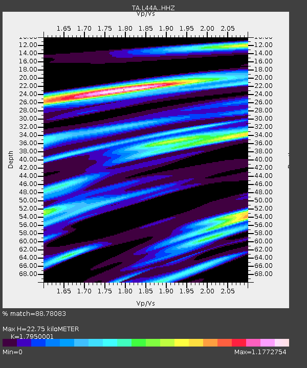
| Estimated Moho Depth: |
22.75 km |
| Estimated Crust Vp/Vs: |
1.80 |
| Assumed Crust Vp: |
6.483 km/s |
| Estimated Crust Vs: |
3.611 km/s |
| Estimated Crust Poisson's Ratio: |
0.27 |
|
| Radial Match: |
88.78083 % |
| Radial Bump: |
326 |
| Transverse Match: |
67.45774 % |
| Transverse Bump: |
400 |
| SOD ConfigId: |
13570011 |
| Insert Time: |
2019-04-29 05:03:36.790 +0000 |
| GWidth: |
2.5 |
| Max Bumps: |
400 |
| Tol: |
0.001 |
|
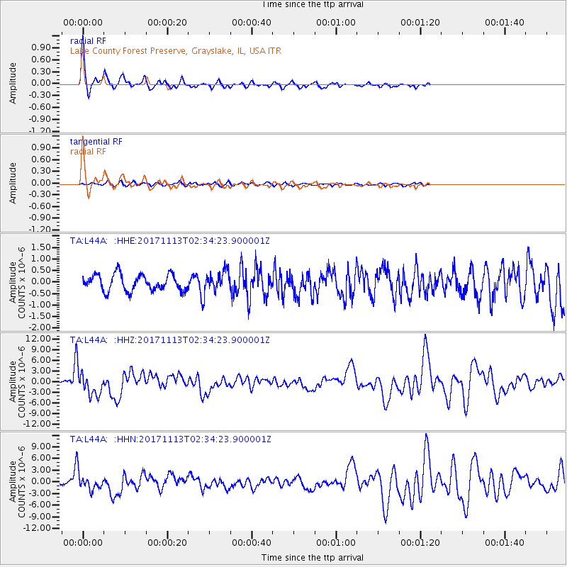
Signal To Noise
| Channel | StoN | STA | LTA |
| TA:L44A: :HHZ:20171113T02:34:23.900001Z | 7.2476983 | 2.9791775E-6 | 4.1105153E-7 |
| TA:L44A: :HHN:20171113T02:34:23.900001Z | 7.8744698 | 1.5435827E-6 | 1.960237E-7 |
| TA:L44A: :HHE:20171113T02:34:23.900001Z | 1.128496 | 3.9758228E-7 | 3.5231164E-7 |
| Arrivals |
| Ps | 3.0 SECOND |
| PpPs | 9.1 SECOND |
| PsPs/PpSs | 12 SECOND |


