You are here: Home > Network List > TA - USArray Transportable Network (new EarthScope stations) Stations List
> Station M53A WI Miller and Sons, Farmdale, OH, USA > Earthquake Result Viewer
M53A WI Miller and Sons, Farmdale, OH, USA - Earthquake Result Viewer
| Earthquake location: |
Costa Rica |
| Earthquake latitude/longitude: |
9.5/-84.5 |
| Earthquake time(UTC): |
2017/11/13 (317) 02:28:23 GMT |
| Earthquake Depth: |
19 km |
| Earthquake Magnitude: |
6.5 mww |
| Earthquake Catalog/Contributor: |
NEIC PDE/us |
|
| Network: |
TA USArray Transportable Network (new EarthScope stations) |
| Station: |
M53A WI Miller and Sons, Farmdale, OH, USA |
| Lat/Lon: |
41.44 N/80.68 W |
| Elevation: |
334 m |
|
| Distance: |
32.0 deg |
| Az: |
5.416 deg |
| Baz: |
187.113 deg |
| Ray Param: |
0.078830466 |
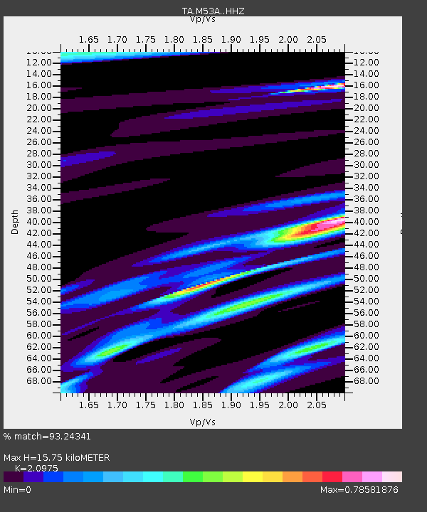
| Estimated Moho Depth: |
15.75 km |
| Estimated Crust Vp/Vs: |
2.10 |
| Assumed Crust Vp: |
6.483 km/s |
| Estimated Crust Vs: |
3.091 km/s |
| Estimated Crust Poisson's Ratio: |
0.35 |
|
| Radial Match: |
93.24341 % |
| Radial Bump: |
213 |
| Transverse Match: |
63.459187 % |
| Transverse Bump: |
400 |
| SOD ConfigId: |
13570011 |
| Insert Time: |
2019-04-29 05:03:50.459 +0000 |
| GWidth: |
2.5 |
| Max Bumps: |
400 |
| Tol: |
0.001 |
|
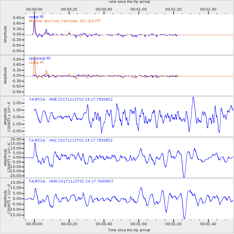
Signal To Noise
| Channel | StoN | STA | LTA |
| TA:M53A: :HHZ:20171113T02:34:17.789985Z | 23.906977 | 6.4148867E-6 | 2.6832697E-7 |
| TA:M53A: :HHN:20171113T02:34:17.789985Z | 13.643904 | 4.2355755E-6 | 3.1043723E-7 |
| TA:M53A: :HHE:20171113T02:34:17.789985Z | 2.0373197 | 8.910095E-7 | 4.37344E-7 |
| Arrivals |
| Ps | 2.9 SECOND |
| PpPs | 7.0 SECOND |
| PsPs/PpSs | 9.9 SECOND |


