You are here: Home > Network List > WY - Yellowstone Wyoming Seismic Network Stations List
> Station YMP Mirror Lake Plateau, YNP, WY, USA > Earthquake Result Viewer
YMP Mirror Lake Plateau, YNP, WY, USA - Earthquake Result Viewer

| Earthquake location: |
Alaska Peninsula |
| Earthquake latitude/longitude: |
57.0/-158.0 |
| Earthquake time(UTC): |
2016/04/02 (093) 05:50:00 GMT |
| Earthquake Depth: |
10 km |
| Earthquake Magnitude: |
6.2 MWP, 6.4 MI |
| Earthquake Catalog/Contributor: |
NEIC PDE/NEIC COMCAT |
|
| Network: |
WY Yellowstone Wyoming Seismic Network |
| Station: |
YMP Mirror Lake Plateau, YNP, WY, USA |
| Lat/Lon: |
44.74 N/110.16 W |
| Elevation: |
2774 m |
|
| Distance: |
31.9 deg |
| Az: |
91.894 deg |
| Baz: |
309.955 deg |
| Ray Param: |
0.07888708 |
| Estimated Moho Depth: |
20.5 km |
| Estimated Crust Vp/Vs: |
2.01 |
| Assumed Crust Vp: |
6.35 km/s |
| Estimated Crust Vs: |
3.163 km/s |
| Estimated Crust Poisson's Ratio: |
0.33 |
|
| Radial Match: |
85.28008 % |
| Radial Bump: |
400 |
| Transverse Match: |
83.423004 % |
| Transverse Bump: |
400 |
| SOD ConfigId: |
1475611 |
| Insert Time: |
2016-04-16 06:45:35.089 +0000 |
| GWidth: |
2.5 |
| Max Bumps: |
400 |
| Tol: |
0.001 |
|
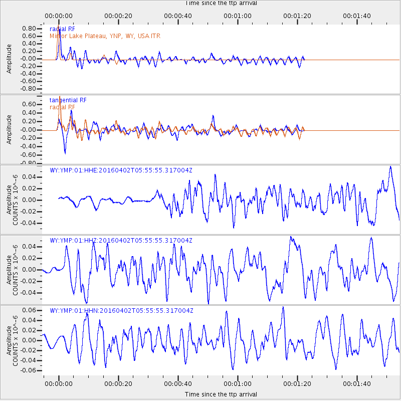
Signal To Noise
| Channel | StoN | STA | LTA |
| WY:YMP:01:HHZ:20160402T05:55:55.317004Z | 7.849659 | 1.9157294E-8 | 2.4405258E-9 |
| WY:YMP:01:HHN:20160402T05:55:55.317004Z | 2.0345738 | 1.2517708E-8 | 6.1524963E-9 |
| WY:YMP:01:HHE:20160402T05:55:55.317004Z | 1.3603376 | 7.744426E-9 | 5.693018E-9 |
| Arrivals |
| Ps | 3.5 SECOND |
| PpPs | 9.1 SECOND |
| PsPs/PpSs | 13 SECOND |


