You are here: Home > Network List > TA - USArray Transportable Network (new EarthScope stations) Stations List
> Station O17K Koliganek, Bristol Bay, AK, USA > Earthquake Result Viewer
O17K Koliganek, Bristol Bay, AK, USA - Earthquake Result Viewer
| Earthquake location: |
Costa Rica |
| Earthquake latitude/longitude: |
9.5/-84.5 |
| Earthquake time(UTC): |
2017/11/13 (317) 02:28:23 GMT |
| Earthquake Depth: |
19 km |
| Earthquake Magnitude: |
6.5 mww |
| Earthquake Catalog/Contributor: |
NEIC PDE/us |
|
| Network: |
TA USArray Transportable Network (new EarthScope stations) |
| Station: |
O17K Koliganek, Bristol Bay, AK, USA |
| Lat/Lon: |
59.77 N/157.09 W |
| Elevation: |
156 m |
|
| Distance: |
73.1 deg |
| Az: |
329.693 deg |
| Baz: |
100.31 deg |
| Ray Param: |
0.05321328 |
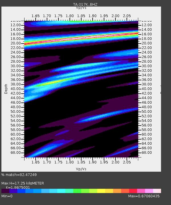
| Estimated Moho Depth: |
17.25 km |
| Estimated Crust Vp/Vs: |
1.87 |
| Assumed Crust Vp: |
6.276 km/s |
| Estimated Crust Vs: |
3.361 km/s |
| Estimated Crust Poisson's Ratio: |
0.30 |
|
| Radial Match: |
82.47249 % |
| Radial Bump: |
391 |
| Transverse Match: |
70.47902 % |
| Transverse Bump: |
400 |
| SOD ConfigId: |
13570011 |
| Insert Time: |
2019-04-29 05:04:02.280 +0000 |
| GWidth: |
2.5 |
| Max Bumps: |
400 |
| Tol: |
0.001 |
|
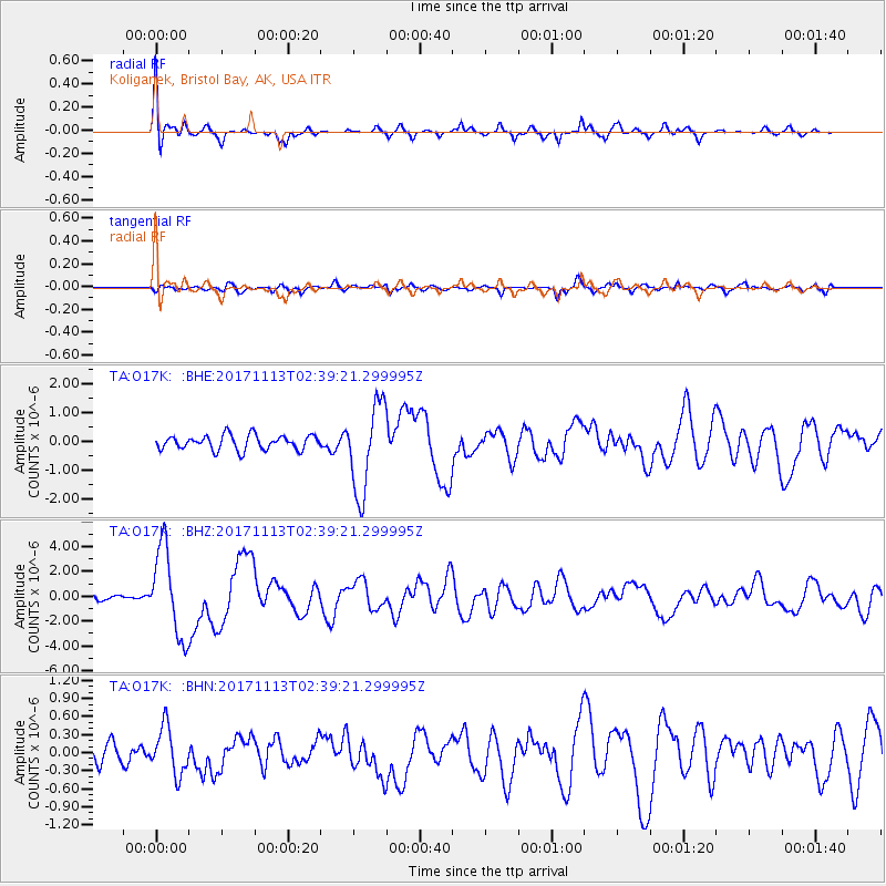
Signal To Noise
| Channel | StoN | STA | LTA |
| TA:O17K: :BHZ:20171113T02:39:21.299995Z | 10.083252 | 3.5324326E-6 | 3.503267E-7 |
| TA:O17K: :BHN:20171113T02:39:21.299995Z | 1.5480412 | 3.890841E-7 | 2.5133963E-7 |
| TA:O17K: :BHE:20171113T02:39:21.299995Z | 6.1575065 | 1.5409239E-6 | 2.502513E-7 |
| Arrivals |
| Ps | 2.5 SECOND |
| PpPs | 7.6 SECOND |
| PsPs/PpSs | 10 SECOND |


