You are here: Home > Network List > TA - USArray Transportable Network (new EarthScope stations) Stations List
> Station Q17K Contact Creek, Katmai, AK, USA > Earthquake Result Viewer
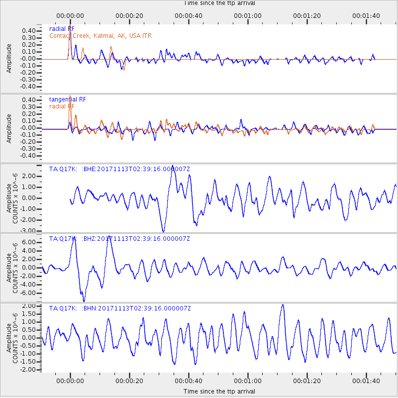
Q17K Contact Creek, Katmai, AK, USA - Earthquake Result Viewer

| Earthquake location: |
Costa Rica |
| Earthquake latitude/longitude: |
9.5/-84.5 |
| Earthquake time(UTC): |
2017/11/13 (317) 02:28:23 GMT |
| Earthquake Depth: |
19 km |
| Earthquake Magnitude: |
6.5 mww |
| Earthquake Catalog/Contributor: |
NEIC PDE/us |
|
| Network: |
TA USArray Transportable Network (new EarthScope stations) |
| Station: |
Q17K Contact Creek, Katmai, AK, USA |
| Lat/Lon: |
58.26 N/155.89 W |
| Elevation: |
1165 m |
|
| Distance: |
72.2 deg |
| Az: |
328.254 deg |
| Baz: |
100.915 deg |
| Ray Param: |
0.053801008 |
| Estimated Moho Depth: |
10.75 km |
| Estimated Crust Vp/Vs: |
2.10 |
| Assumed Crust Vp: |
6.438 km/s |
| Estimated Crust Vs: |
3.069 km/s |
| Estimated Crust Poisson's Ratio: |
0.35 |
|
| Radial Match: |
82.732 % |
| Radial Bump: |
400 |
| Transverse Match: |
72.18956 % |
| Transverse Bump: |
400 |
| SOD ConfigId: |
13570011 |
| Insert Time: |
2019-04-29 05:04:28.137 +0000 |
| GWidth: |
2.5 |
| Max Bumps: |
400 |
| Tol: |
0.001 |
|
Signal To Noise
| Channel | StoN | STA | LTA |
| TA:Q17K: :BHZ:20171113T02:39:16.000007Z | 7.467157 | 4.9349956E-6 | 6.6089353E-7 |
| TA:Q17K: :BHN:20171113T02:39:16.000007Z | 1.1140997 | 7.0676316E-7 | 6.343805E-7 |
| TA:Q17K: :BHE:20171113T02:39:16.000007Z | 4.406613 | 1.932144E-6 | 4.3846464E-7 |
| Arrivals |
| Ps | 1.9 SECOND |
| PpPs | 5.0 SECOND |
| PsPs/PpSs | 6.9 SECOND |


