You are here: Home > Network List > TA - USArray Transportable Network (new EarthScope stations) Stations List
> Station T25A Trinidad, CO, USA > Earthquake Result Viewer
T25A Trinidad, CO, USA - Earthquake Result Viewer

| Earthquake location: |
Costa Rica |
| Earthquake latitude/longitude: |
9.5/-84.5 |
| Earthquake time(UTC): |
2017/11/13 (317) 02:28:23 GMT |
| Earthquake Depth: |
19 km |
| Earthquake Magnitude: |
6.5 mww |
| Earthquake Catalog/Contributor: |
NEIC PDE/us |
|
| Network: |
TA USArray Transportable Network (new EarthScope stations) |
| Station: |
T25A Trinidad, CO, USA |
| Lat/Lon: |
37.14 N/104.41 W |
| Elevation: |
2017 m |
|
| Distance: |
32.9 deg |
| Az: |
329.892 deg |
| Baz: |
141.742 deg |
| Ray Param: |
0.07844509 |
| Estimated Moho Depth: |
62.0 km |
| Estimated Crust Vp/Vs: |
1.60 |
| Assumed Crust Vp: |
6.316 km/s |
| Estimated Crust Vs: |
3.947 km/s |
| Estimated Crust Poisson's Ratio: |
0.18 |
|
| Radial Match: |
94.00977 % |
| Radial Bump: |
148 |
| Transverse Match: |
79.012764 % |
| Transverse Bump: |
294 |
| SOD ConfigId: |
13570011 |
| Insert Time: |
2019-04-29 05:04:40.050 +0000 |
| GWidth: |
2.5 |
| Max Bumps: |
400 |
| Tol: |
0.001 |
|
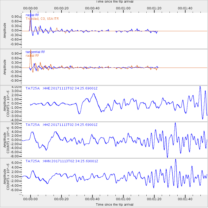
Signal To Noise
| Channel | StoN | STA | LTA |
| TA:T25A: :HHZ:20171113T02:34:25.69001Z | 13.284322 | 2.405713E-6 | 1.8109415E-7 |
| TA:T25A: :HHN:20171113T02:34:25.69001Z | 5.5557857 | 1.4659462E-6 | 2.638594E-7 |
| TA:T25A: :HHE:20171113T02:34:25.69001Z | 6.1485724 | 1.2917901E-6 | 2.1009593E-7 |
| Arrivals |
| Ps | 6.4 SECOND |
| PpPs | 23 SECOND |
| PsPs/PpSs | 30 SECOND |


