You are here: Home > Network List > TA - USArray Transportable Network (new EarthScope stations) Stations List
> Station TPFO Pinon Flats, CA, USA > Earthquake Result Viewer
TPFO Pinon Flats, CA, USA - Earthquake Result Viewer
| Earthquake location: |
Costa Rica |
| Earthquake latitude/longitude: |
9.5/-84.5 |
| Earthquake time(UTC): |
2017/11/13 (317) 02:28:23 GMT |
| Earthquake Depth: |
19 km |
| Earthquake Magnitude: |
6.5 mww |
| Earthquake Catalog/Contributor: |
NEIC PDE/us |
|
| Network: |
TA USArray Transportable Network (new EarthScope stations) |
| Station: |
TPFO Pinon Flats, CA, USA |
| Lat/Lon: |
33.61 N/116.45 W |
| Elevation: |
1275 m |
|
| Distance: |
37.9 deg |
| Az: |
314.03 deg |
| Baz: |
121.811 deg |
| Ray Param: |
0.07583709 |
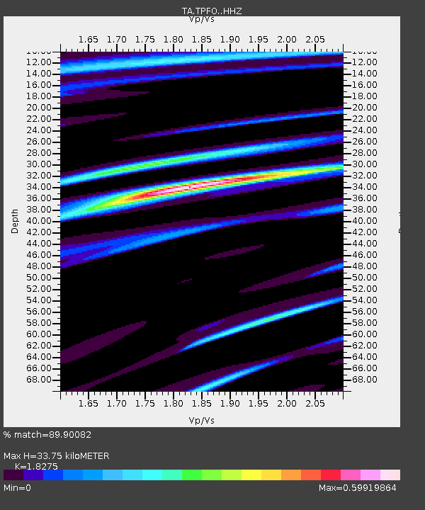
| Estimated Moho Depth: |
33.75 km |
| Estimated Crust Vp/Vs: |
1.83 |
| Assumed Crust Vp: |
6.264 km/s |
| Estimated Crust Vs: |
3.427 km/s |
| Estimated Crust Poisson's Ratio: |
0.29 |
|
| Radial Match: |
89.90082 % |
| Radial Bump: |
272 |
| Transverse Match: |
73.5206 % |
| Transverse Bump: |
400 |
| SOD ConfigId: |
13570011 |
| Insert Time: |
2019-04-29 05:04:43.253 +0000 |
| GWidth: |
2.5 |
| Max Bumps: |
400 |
| Tol: |
0.001 |
|
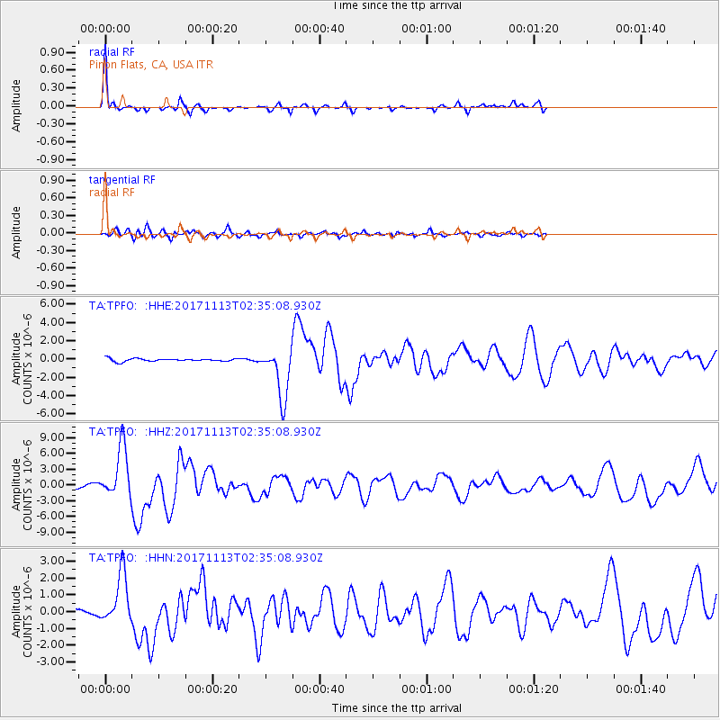
Signal To Noise
| Channel | StoN | STA | LTA |
| TA:TPFO: :HHZ:20171113T02:35:08.930Z | 16.193172 | 4.9833698E-6 | 3.0774513E-7 |
| TA:TPFO: :HHN:20171113T02:35:08.930Z | 6.17991 | 1.5617779E-6 | 2.5271856E-7 |
| TA:TPFO: :HHE:20171113T02:35:08.930Z | 18.17969 | 2.8531917E-6 | 1.5694393E-7 |
| Arrivals |
| Ps | 4.8 SECOND |
| PpPs | 14 SECOND |
| PsPs/PpSs | 19 SECOND |


