You are here: Home > Network List > TA - USArray Transportable Network (new EarthScope stations) Stations List
> Station W18A Petrified Forest, AZ, USA > Earthquake Result Viewer
W18A Petrified Forest, AZ, USA - Earthquake Result Viewer
| Earthquake location: |
Costa Rica |
| Earthquake latitude/longitude: |
9.5/-84.5 |
| Earthquake time(UTC): |
2017/11/13 (317) 02:28:23 GMT |
| Earthquake Depth: |
19 km |
| Earthquake Magnitude: |
6.5 mww |
| Earthquake Catalog/Contributor: |
NEIC PDE/us |
|
| Network: |
TA USArray Transportable Network (new EarthScope stations) |
| Station: |
W18A Petrified Forest, AZ, USA |
| Lat/Lon: |
35.12 N/109.74 W |
| Elevation: |
1750 m |
|
| Distance: |
34.4 deg |
| Az: |
321.723 deg |
| Baz: |
131.807 deg |
| Ray Param: |
0.07775635 |
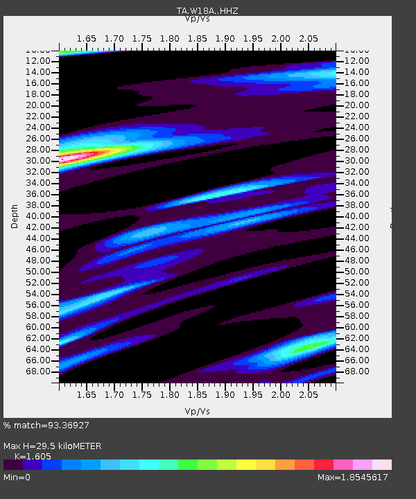
| Estimated Moho Depth: |
29.5 km |
| Estimated Crust Vp/Vs: |
1.61 |
| Assumed Crust Vp: |
6.496 km/s |
| Estimated Crust Vs: |
4.047 km/s |
| Estimated Crust Poisson's Ratio: |
0.18 |
|
| Radial Match: |
93.36927 % |
| Radial Bump: |
296 |
| Transverse Match: |
62.44144 % |
| Transverse Bump: |
400 |
| SOD ConfigId: |
13570011 |
| Insert Time: |
2019-04-29 05:04:45.540 +0000 |
| GWidth: |
2.5 |
| Max Bumps: |
400 |
| Tol: |
0.001 |
|

Signal To Noise
| Channel | StoN | STA | LTA |
| TA:W18A: :HHZ:20171113T02:34:38.600013Z | 23.13513 | 4.2374154E-6 | 1.8315936E-7 |
| TA:W18A: :HHN:20171113T02:34:38.600013Z | 5.9930835 | 1.5746526E-6 | 2.62745E-7 |
| TA:W18A: :HHE:20171113T02:34:38.600013Z | 13.444946 | 2.1437436E-6 | 1.5944605E-7 |
| Arrivals |
| Ps | 3.0 SECOND |
| PpPs | 11 SECOND |
| PsPs/PpSs | 14 SECOND |


