You are here: Home > Network List > XU16 - USGS NEHRP Proposal 2016-2018 - Greeley, CO Stations List
> Station GR02 Grover West, CO, USA > Earthquake Result Viewer
GR02 Grover West, CO, USA - Earthquake Result Viewer
| Earthquake location: |
Costa Rica |
| Earthquake latitude/longitude: |
9.5/-84.5 |
| Earthquake time(UTC): |
2017/11/13 (317) 02:28:23 GMT |
| Earthquake Depth: |
19 km |
| Earthquake Magnitude: |
6.5 mww |
| Earthquake Catalog/Contributor: |
NEIC PDE/us |
|
| Network: |
XU USGS NEHRP Proposal 2016-2018 - Greeley, CO |
| Station: |
GR02 Grover West, CO, USA |
| Lat/Lon: |
40.89 N/104.35 W |
| Elevation: |
1576 m |
|
| Distance: |
35.9 deg |
| Az: |
333.913 deg |
| Baz: |
145.098 deg |
| Ray Param: |
0.076969266 |
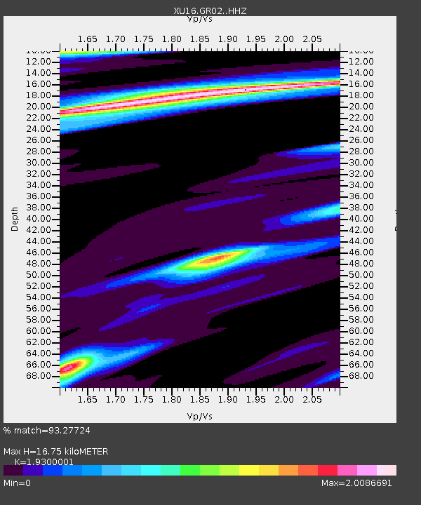
| Estimated Moho Depth: |
16.75 km |
| Estimated Crust Vp/Vs: |
1.93 |
| Assumed Crust Vp: |
6.306 km/s |
| Estimated Crust Vs: |
3.267 km/s |
| Estimated Crust Poisson's Ratio: |
0.32 |
|
| Radial Match: |
93.27724 % |
| Radial Bump: |
229 |
| Transverse Match: |
65.22986 % |
| Transverse Bump: |
374 |
| SOD ConfigId: |
13570011 |
| Insert Time: |
2019-04-29 05:06:02.734 +0000 |
| GWidth: |
2.5 |
| Max Bumps: |
400 |
| Tol: |
0.001 |
|

Signal To Noise
| Channel | StoN | STA | LTA |
| XU:GR02: :HHZ:20171113T02:34:51.479988Z | 9.929537 | 3.976159E-6 | 4.004375E-7 |
| XU:GR02: :HH1:20171113T02:34:51.479988Z | 3.1431468 | 2.5062718E-6 | 7.9737663E-7 |
| XU:GR02: :HH2:20171113T02:34:51.479988Z | 1.5562888 | 1.661753E-6 | 1.0677664E-6 |
| Arrivals |
| Ps | 2.6 SECOND |
| PpPs | 7.3 SECOND |
| PsPs/PpSs | 9.9 SECOND |


