You are here: Home > Network List > TA - USArray Transportable Network (new EarthScope stations) Stations List
> Station N25K Chitina, Valdez-Cordova, AK, USA > Earthquake Result Viewer
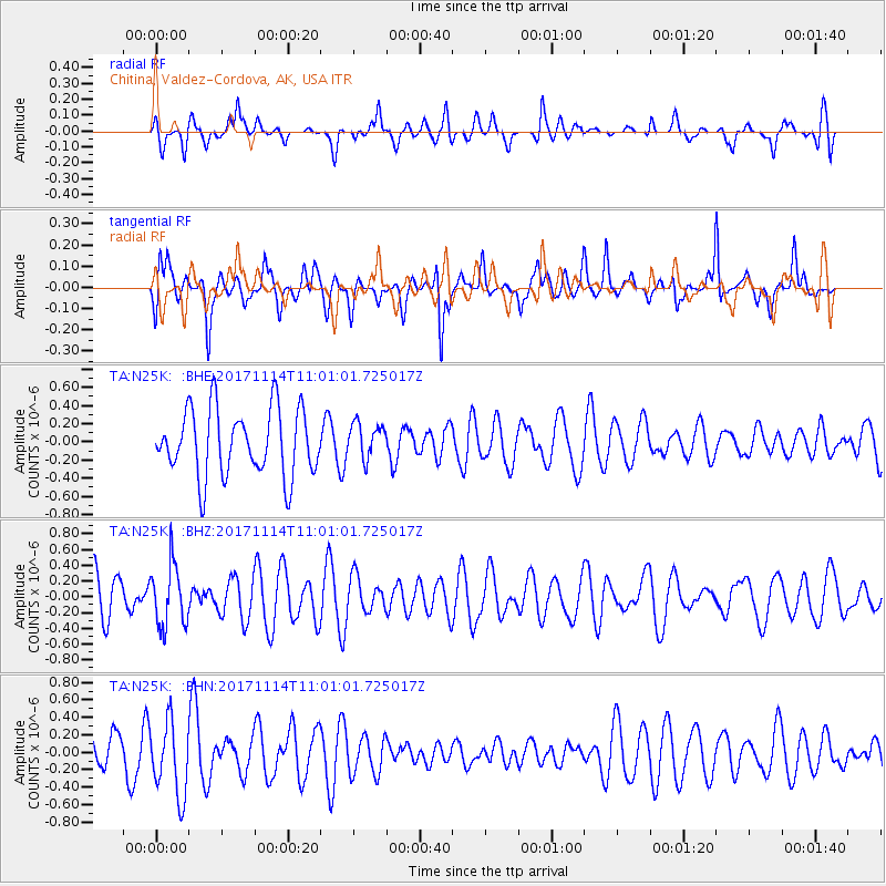
N25K Chitina, Valdez-Cordova, AK, USA - Earthquake Result Viewer
*The percent match for this event was below the threshold and hence no stack was calculated.
| Earthquake location: |
Fiji Islands Region |
| Earthquake latitude/longitude: |
-18.2/-178.0 |
| Earthquake time(UTC): |
2017/11/14 (318) 10:50:05 GMT |
| Earthquake Depth: |
604 km |
| Earthquake Magnitude: |
5.5 Mww |
| Earthquake Catalog/Contributor: |
NEIC PDE/us |
|
| Network: |
TA USArray Transportable Network (new EarthScope stations) |
| Station: |
N25K Chitina, Valdez-Cordova, AK, USA |
| Lat/Lon: |
61.61 N/144.60 W |
| Elevation: |
1087 m |
|
| Distance: |
83.8 deg |
| Az: |
15.342 deg |
| Baz: |
211.756 deg |
| Ray Param: |
$rayparam |
*The percent match for this event was below the threshold and hence was not used in the summary stack. |
|
| Radial Match: |
44.607635 % |
| Radial Bump: |
400 |
| Transverse Match: |
61.788654 % |
| Transverse Bump: |
400 |
| SOD ConfigId: |
13570011 |
| Insert Time: |
2019-04-29 05:11:39.941 +0000 |
| GWidth: |
2.5 |
| Max Bumps: |
400 |
| Tol: |
0.001 |
|
Signal To Noise
| Channel | StoN | STA | LTA |
| TA:N25K: :BHZ:20171114T11:01:01.725017Z | 1.3608004 | 3.9058614E-7 | 2.8702678E-7 |
| TA:N25K: :BHN:20171114T11:01:01.725017Z | 2.326269 | 4.2301616E-7 | 1.8184319E-7 |
| TA:N25K: :BHE:20171114T11:01:01.725017Z | 0.5250089 | 1.9363166E-7 | 3.6881596E-7 |
| Arrivals |
| Ps | |
| PpPs | |
| PsPs/PpSs | |


