You are here: Home > Network List > TA - USArray Transportable Network (new EarthScope stations) Stations List
> Station K20A Yellowstone Ranch, Lander, WY, USA > Earthquake Result Viewer
K20A Yellowstone Ranch, Lander, WY, USA - Earthquake Result Viewer
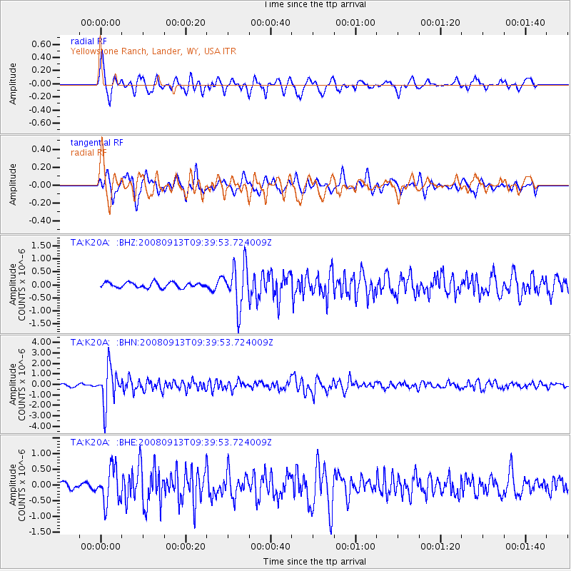
| Earthquake location: |
Colombia |
| Earthquake latitude/longitude: |
4.8/-75.5 |
| Earthquake time(UTC): |
2008/09/13 (257) 09:32:01 GMT |
| Earthquake Depth: |
133 km |
| Earthquake Magnitude: |
5.9 MB, 5.7 MW, 5.7 MW |
| Earthquake Catalog/Contributor: |
WHDF/NEIC |
|
| Network: |
TA USArray Transportable Network (new EarthScope stations) |
| Station: |
K20A Yellowstone Ranch, Lander, WY, USA |
| Lat/Lon: |
42.66 N/108.34 W |
| Elevation: |
1736 m |
|
| Distance: |
47.6 deg |
| Az: |
327.239 deg |
| Baz: |
133.026 deg |
| Ray Param: |
0.06941005 |
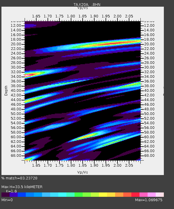
| Estimated Moho Depth: |
33.5 km |
| Estimated Crust Vp/Vs: |
1.60 |
| Assumed Crust Vp: |
6.161 km/s |
| Estimated Crust Vs: |
3.851 km/s |
| Estimated Crust Poisson's Ratio: |
0.18 |
|
| Radial Match: |
83.23728 % |
| Radial Bump: |
400 |
| Transverse Match: |
76.34965 % |
| Transverse Bump: |
400 |
| SOD ConfigId: |
2560 |
| Insert Time: |
2010-03-06 06:28:35.496 +0000 |
| GWidth: |
2.5 |
| Max Bumps: |
400 |
| Tol: |
0.001 |
|
Signal To Noise
| Channel | StoN | STA | LTA |
| TA:K20A: :BHN:20080913T09:39:53.724009Z | 19.569365 | 1.8025672E-6 | 9.21117E-8 |
| TA:K20A: :BHE:20080913T09:39:53.724009Z | 3.837029 | 5.741793E-7 | 1.4964164E-7 |
| TA:K20A: :BHZ:20080913T09:39:53.724009Z | 8.19639 | 8.308768E-7 | 1.01371064E-7 |
| Arrivals |
| Ps | 3.5 SECOND |
| PpPs | 13 SECOND |
| PsPs/PpSs | 17 SECOND |


