You are here: Home > Network List > TA - USArray Transportable Network (new EarthScope stations) Stations List
> Station K20A Yellowstone Ranch, Lander, WY, USA > Earthquake Result Viewer
K20A Yellowstone Ranch, Lander, WY, USA - Earthquake Result Viewer
| Earthquake location: |
East Of Kuril Islands |
| Earthquake latitude/longitude: |
46.9/155.2 |
| Earthquake time(UTC): |
2009/01/15 (015) 17:49:39 GMT |
| Earthquake Depth: |
36 km |
| Earthquake Magnitude: |
6.9 MB, 7.5 MS, 7.4 MW, 7.4 MW |
| Earthquake Catalog/Contributor: |
WHDF/NEIC |
|
| Network: |
TA USArray Transportable Network (new EarthScope stations) |
| Station: |
K20A Yellowstone Ranch, Lander, WY, USA |
| Lat/Lon: |
42.66 N/108.34 W |
| Elevation: |
1736 m |
|
| Distance: |
64.3 deg |
| Az: |
54.432 deg |
| Baz: |
310.823 deg |
| Ray Param: |
0.058952834 |
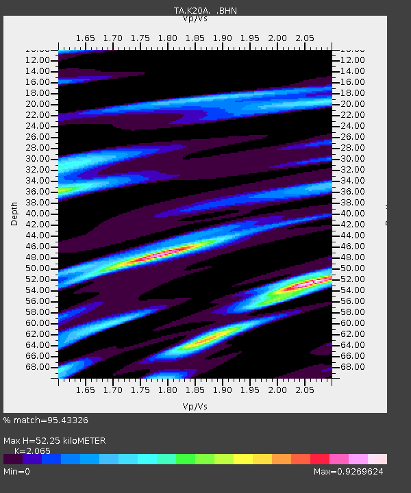
| Estimated Moho Depth: |
52.25 km |
| Estimated Crust Vp/Vs: |
2.07 |
| Assumed Crust Vp: |
6.161 km/s |
| Estimated Crust Vs: |
2.983 km/s |
| Estimated Crust Poisson's Ratio: |
0.35 |
|
| Radial Match: |
95.43326 % |
| Radial Bump: |
395 |
| Transverse Match: |
82.272964 % |
| Transverse Bump: |
400 |
| SOD ConfigId: |
2834 |
| Insert Time: |
2010-03-06 06:28:51.516 +0000 |
| GWidth: |
2.5 |
| Max Bumps: |
400 |
| Tol: |
0.001 |
|
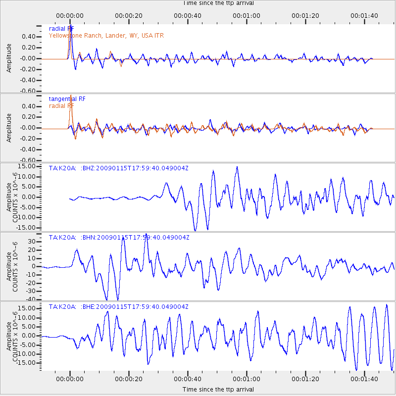
Signal To Noise
| Channel | StoN | STA | LTA |
| TA:K20A: :BHN:20090115T17:59:40.049004Z | 29.326925 | 1.0527073E-5 | 3.589559E-7 |
| TA:K20A: :BHE:20090115T17:59:40.049004Z | 8.086431 | 3.033199E-6 | 3.750974E-7 |
| TA:K20A: :BHZ:20090115T17:59:40.049004Z | 8.696474 | 3.7822356E-6 | 4.34916E-7 |
| Arrivals |
| Ps | 9.3 SECOND |
| PpPs | 25 SECOND |
| PsPs/PpSs | 34 SECOND |


