You are here: Home > Network List > CN - Canadian National Seismograph Network Stations List
> Station INK INUVIK, NT > Earthquake Result Viewer
INK INUVIK, NT - Earthquake Result Viewer
*The percent match for this event was below the threshold and hence no stack was calculated.
| Earthquake location: |
Tonga Islands Region |
| Earthquake latitude/longitude: |
-18.6/-171.5 |
| Earthquake time(UTC): |
2017/11/14 (318) 18:44:00 GMT |
| Earthquake Depth: |
10 km |
| Earthquake Magnitude: |
5.4 Mww |
| Earthquake Catalog/Contributor: |
NEIC PDE/us |
|
| Network: |
CN Canadian National Seismograph Network |
| Station: |
INK INUVIK, NT |
| Lat/Lon: |
68.31 N/133.53 W |
| Elevation: |
44 m |
|
| Distance: |
91.0 deg |
| Az: |
13.23 deg |
| Baz: |
215.716 deg |
| Ray Param: |
$rayparam |
*The percent match for this event was below the threshold and hence was not used in the summary stack. |
|
| Radial Match: |
32.985046 % |
| Radial Bump: |
400 |
| Transverse Match: |
30.766197 % |
| Transverse Bump: |
400 |
| SOD ConfigId: |
13570011 |
| Insert Time: |
2019-04-29 05:15:46.356 +0000 |
| GWidth: |
2.5 |
| Max Bumps: |
400 |
| Tol: |
0.001 |
|
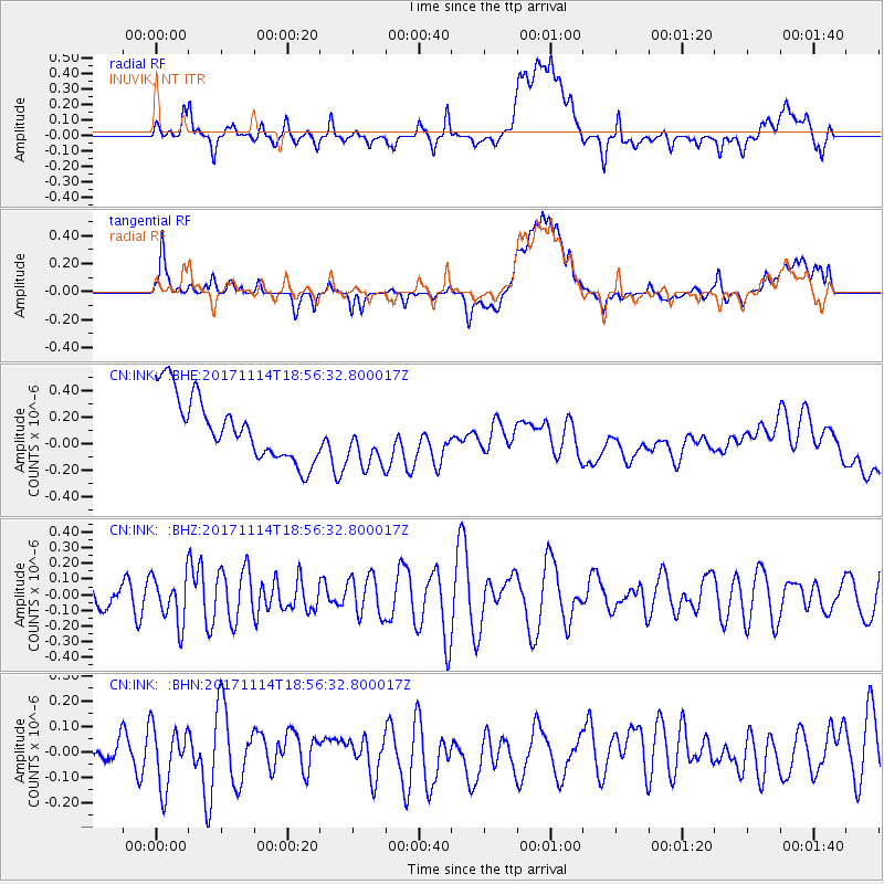
Signal To Noise
| Channel | StoN | STA | LTA |
| CN:INK: :BHZ:20171114T18:56:32.800017Z | 1.9832487 | 1.5144916E-7 | 7.6364174E-8 |
| CN:INK: :BHN:20171114T18:56:32.800017Z | 1.0137056 | 1.2056726E-7 | 1.1893716E-7 |
| CN:INK: :BHE:20171114T18:56:32.800017Z | 0.91031134 | 2.1656157E-7 | 2.3789836E-7 |
| Arrivals |
| Ps | |
| PpPs | |
| PsPs/PpSs | |


