You are here: Home > Network List > TA - USArray Transportable Network (new EarthScope stations) Stations List
> Station K20A Yellowstone Ranch, Lander, WY, USA > Earthquake Result Viewer
K20A Yellowstone Ranch, Lander, WY, USA - Earthquake Result Viewer
| Earthquake location: |
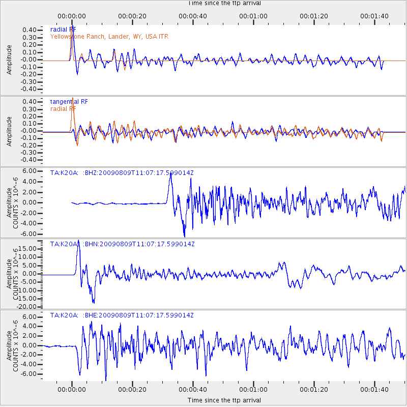
Near S. Coast Of Honshu, Japan |
| Earthquake latitude/longitude: |
33.2/137.9 |
| Earthquake time(UTC): |
2009/08/09 (221) 10:55:55 GMT |
| Earthquake Depth: |
297 km |
| Earthquake Magnitude: |
6.5 MB, 7.1 MW, 7.1 MW |
| Earthquake Catalog/Contributor: |
WHDF/NEIC |
|
| Network: |
TA USArray Transportable Network (new EarthScope stations) |
| Station: |
K20A Yellowstone Ranch, Lander, WY, USA |
| Lat/Lon: |
42.66 N/108.34 W |
| Elevation: |
1736 m |
|
| Distance: |
83.2 deg |
| Az: |
42.858 deg |
| Baz: |
309.341 deg |
| Ray Param: |
0.045610722 |
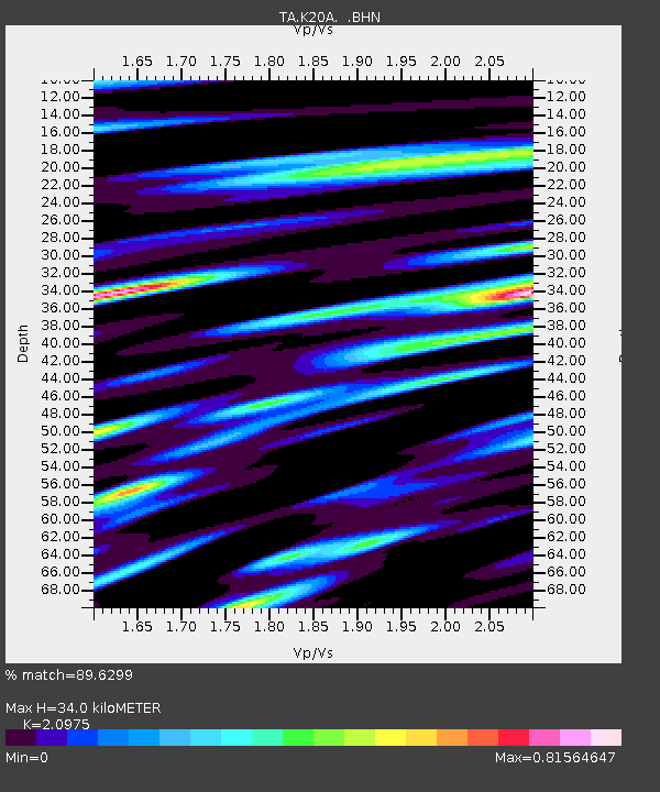
| Estimated Moho Depth: |
34.0 km |
| Estimated Crust Vp/Vs: |
2.10 |
| Assumed Crust Vp: |
6.161 km/s |
| Estimated Crust Vs: |
2.937 km/s |
| Estimated Crust Poisson's Ratio: |
0.35 |
|
| Radial Match: |
89.6299 % |
| Radial Bump: |
400 |
| Transverse Match: |
77.30103 % |
| Transverse Bump: |
400 |
| SOD ConfigId: |
2622 |
| Insert Time: |
2010-03-06 06:28:56.149 +0000 |
| GWidth: |
2.5 |
| Max Bumps: |
400 |
| Tol: |
0.001 |
|
Signal To Noise
| Channel | StoN | STA | LTA |
| TA:K20A: :BHN:20090809T11:07:17.599014Z | 99.51849 | 7.911253E-6 | 7.94953E-8 |
| TA:K20A: :BHE:20090809T11:07:17.599014Z | 29.953444 | 2.4812177E-6 | 8.2835804E-8 |
| TA:K20A: :BHZ:20090809T11:07:17.599014Z | 26.463089 | 2.31385E-6 | 8.743689E-8 |
| Arrivals |
| Ps | 6.2 SECOND |
| PpPs | 17 SECOND |
| PsPs/PpSs | 23 SECOND |


