You are here: Home > Network List > TA - USArray Transportable Network (new EarthScope stations) Stations List
> Station K20A Yellowstone Ranch, Lander, WY, USA > Earthquake Result Viewer
K20A Yellowstone Ranch, Lander, WY, USA - Earthquake Result Viewer
| Earthquake location: |
Tonga Islands |
| Earthquake latitude/longitude: |
-16.3/-173.5 |
| Earthquake time(UTC): |
2009/10/02 (275) 01:07:39 GMT |
| Earthquake Depth: |
8.0 km |
| Earthquake Magnitude: |
6.1 MB, 6.0 MS, 6.1 MW, 6.1 MW |
| Earthquake Catalog/Contributor: |
WHDF/NEIC |
|
| Network: |
TA USArray Transportable Network (new EarthScope stations) |
| Station: |
K20A Yellowstone Ranch, Lander, WY, USA |
| Lat/Lon: |
42.66 N/108.34 W |
| Elevation: |
1736 m |
|
| Distance: |
83.7 deg |
| Az: |
42.321 deg |
| Baz: |
241.203 deg |
| Ray Param: |
0.045981698 |
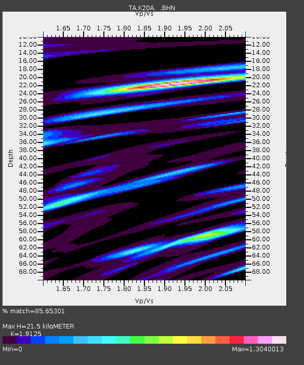
| Estimated Moho Depth: |
21.5 km |
| Estimated Crust Vp/Vs: |
1.91 |
| Assumed Crust Vp: |
6.161 km/s |
| Estimated Crust Vs: |
3.221 km/s |
| Estimated Crust Poisson's Ratio: |
0.31 |
|
| Radial Match: |
85.65301 % |
| Radial Bump: |
349 |
| Transverse Match: |
76.92655 % |
| Transverse Bump: |
400 |
| SOD ConfigId: |
2622 |
| Insert Time: |
2010-03-06 06:29:10.357 +0000 |
| GWidth: |
2.5 |
| Max Bumps: |
400 |
| Tol: |
0.001 |
|

Signal To Noise
| Channel | StoN | STA | LTA |
| TA:K20A: :BHN:20091002T01:19:37.200002Z | 9.626896 | 1.598917E-6 | 1.6608853E-7 |
| TA:K20A: :BHE:20091002T01:19:37.200002Z | 1.7530373 | 4.1587148E-7 | 2.372291E-7 |
| TA:K20A: :BHZ:20091002T01:19:37.200002Z | 2.9841049 | 3.5563602E-7 | 1.19176775E-7 |
| Arrivals |
| Ps | 3.3 SECOND |
| PpPs | 9.9 SECOND |
| PsPs/PpSs | 13 SECOND |


