You are here: Home > Network List > TA - USArray Transportable Network (new EarthScope stations) Stations List
> Station 121A Cookes Peak, Deming, NM, USA > Earthquake Result Viewer
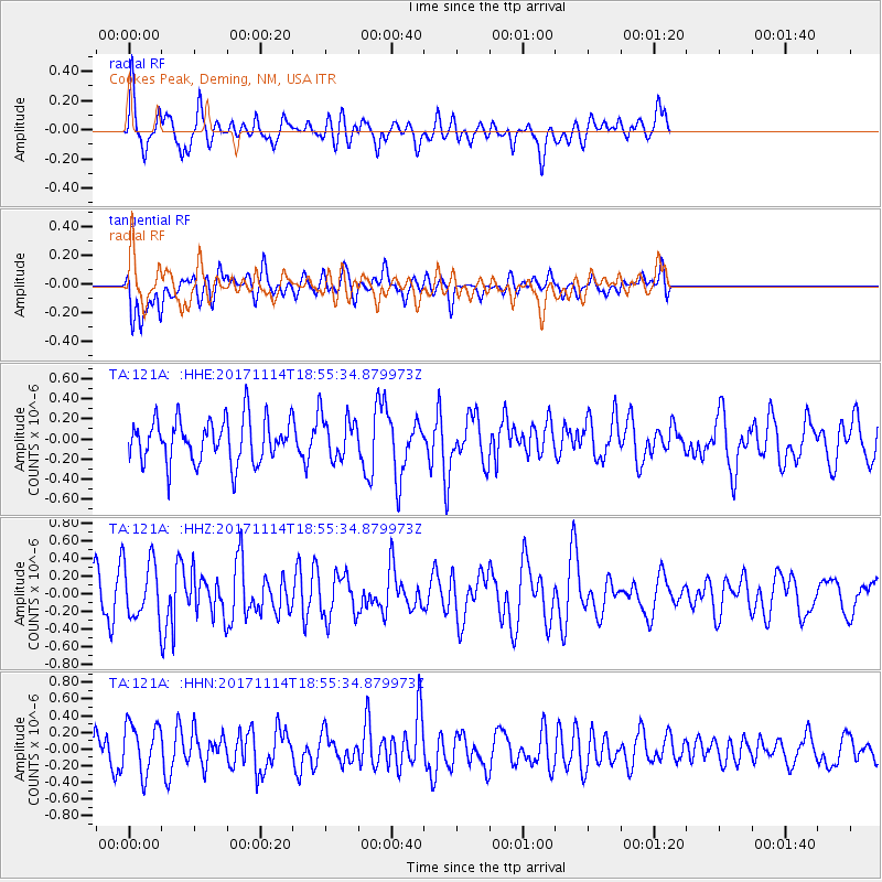
121A Cookes Peak, Deming, NM, USA - Earthquake Result Viewer
*The percent match for this event was below the threshold and hence no stack was calculated.
| Earthquake location: |
Tonga Islands Region |
| Earthquake latitude/longitude: |
-18.6/-171.5 |
| Earthquake time(UTC): |
2017/11/14 (318) 18:44:00 GMT |
| Earthquake Depth: |
10 km |
| Earthquake Magnitude: |
5.4 Mww |
| Earthquake Catalog/Contributor: |
NEIC PDE/us |
|
| Network: |
TA USArray Transportable Network (new EarthScope stations) |
| Station: |
121A Cookes Peak, Deming, NM, USA |
| Lat/Lon: |
32.53 N/107.79 W |
| Elevation: |
1652 m |
|
| Distance: |
79.4 deg |
| Az: |
50.42 deg |
| Baz: |
239.912 deg |
| Ray Param: |
$rayparam |
*The percent match for this event was below the threshold and hence was not used in the summary stack. |
|
| Radial Match: |
66.6951 % |
| Radial Bump: |
400 |
| Transverse Match: |
52.96539 % |
| Transverse Bump: |
400 |
| SOD ConfigId: |
13570011 |
| Insert Time: |
2019-04-29 05:18:36.031 +0000 |
| GWidth: |
2.5 |
| Max Bumps: |
400 |
| Tol: |
0.001 |
|
Signal To Noise
| Channel | StoN | STA | LTA |
| TA:121A: :HHZ:20171114T18:55:34.879973Z | 1.5860791 | 3.258889E-7 | 2.0546824E-7 |
| TA:121A: :HHN:20171114T18:55:34.879973Z | 1.4778703 | 2.970778E-7 | 2.010175E-7 |
| TA:121A: :HHE:20171114T18:55:34.879973Z | 1.0603151 | 2.2698666E-7 | 2.140747E-7 |
| Arrivals |
| Ps | |
| PpPs | |
| PsPs/PpSs | |


