You are here: Home > Network List > TA - USArray Transportable Network (new EarthScope stations) Stations List
> Station G23K Bananza Creek, AK, USA > Earthquake Result Viewer
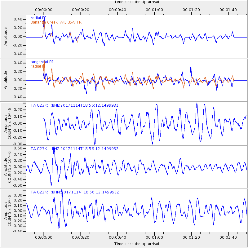
G23K Bananza Creek, AK, USA - Earthquake Result Viewer
*The percent match for this event was below the threshold and hence no stack was calculated.
| Earthquake location: |
Tonga Islands Region |
| Earthquake latitude/longitude: |
-18.6/-171.5 |
| Earthquake time(UTC): |
2017/11/14 (318) 18:44:00 GMT |
| Earthquake Depth: |
10 km |
| Earthquake Magnitude: |
5.4 Mww |
| Earthquake Catalog/Contributor: |
NEIC PDE/us |
|
| Network: |
TA USArray Transportable Network (new EarthScope stations) |
| Station: |
G23K Bananza Creek, AK, USA |
| Lat/Lon: |
66.71 N/150.02 W |
| Elevation: |
746 m |
|
| Distance: |
86.6 deg |
| Az: |
8.391 deg |
| Baz: |
200.366 deg |
| Ray Param: |
$rayparam |
*The percent match for this event was below the threshold and hence was not used in the summary stack. |
|
| Radial Match: |
61.73308 % |
| Radial Bump: |
400 |
| Transverse Match: |
63.830544 % |
| Transverse Bump: |
400 |
| SOD ConfigId: |
13570011 |
| Insert Time: |
2019-04-29 05:18:48.316 +0000 |
| GWidth: |
2.5 |
| Max Bumps: |
400 |
| Tol: |
0.001 |
|
Signal To Noise
| Channel | StoN | STA | LTA |
| TA:G23K: :BHZ:20171114T18:56:12.149993Z | 1.831752 | 2.3892278E-7 | 1.3043403E-7 |
| TA:G23K: :BHN:20171114T18:56:12.149993Z | 0.76755846 | 9.363386E-8 | 1.2198923E-7 |
| TA:G23K: :BHE:20171114T18:56:12.149993Z | 1.2187345 | 9.95605E-8 | 8.16917E-8 |
| Arrivals |
| Ps | |
| PpPs | |
| PsPs/PpSs | |


