You are here: Home > Network List > TA - USArray Transportable Network (new EarthScope stations) Stations List
> Station J26L Joseph Creek, AK, USA > Earthquake Result Viewer
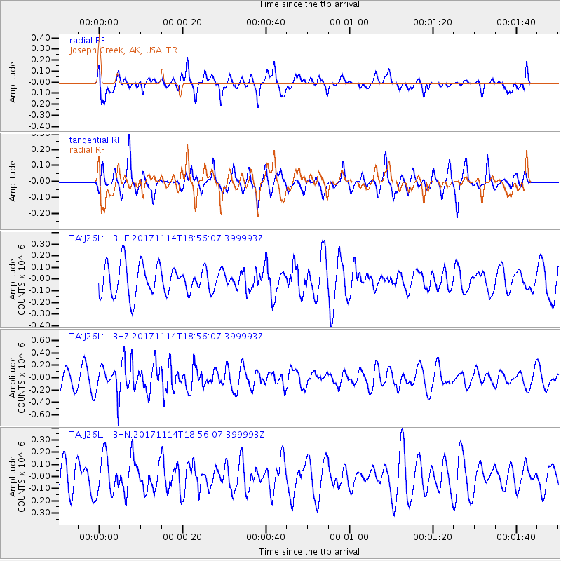
J26L Joseph Creek, AK, USA - Earthquake Result Viewer
*The percent match for this event was below the threshold and hence no stack was calculated.
| Earthquake location: |
Tonga Islands Region |
| Earthquake latitude/longitude: |
-18.6/-171.5 |
| Earthquake time(UTC): |
2017/11/14 (318) 18:44:00 GMT |
| Earthquake Depth: |
10 km |
| Earthquake Magnitude: |
5.4 Mww |
| Earthquake Catalog/Contributor: |
NEIC PDE/us |
|
| Network: |
TA USArray Transportable Network (new EarthScope stations) |
| Station: |
J26L Joseph Creek, AK, USA |
| Lat/Lon: |
64.50 N/143.56 W |
| Elevation: |
1144 m |
|
| Distance: |
85.6 deg |
| Az: |
11.74 deg |
| Baz: |
206.474 deg |
| Ray Param: |
$rayparam |
*The percent match for this event was below the threshold and hence was not used in the summary stack. |
|
| Radial Match: |
50.557518 % |
| Radial Bump: |
363 |
| Transverse Match: |
41.104504 % |
| Transverse Bump: |
291 |
| SOD ConfigId: |
13570011 |
| Insert Time: |
2019-04-29 05:18:56.951 +0000 |
| GWidth: |
2.5 |
| Max Bumps: |
400 |
| Tol: |
0.001 |
|
Signal To Noise
| Channel | StoN | STA | LTA |
| TA:J26L: :BHZ:20171114T18:56:07.399993Z | 1.5099452 | 2.2934256E-7 | 1.51888E-7 |
| TA:J26L: :BHN:20171114T18:56:07.399993Z | 1.1444011 | 1.5485715E-7 | 1.3531721E-7 |
| TA:J26L: :BHE:20171114T18:56:07.399993Z | 0.5032353 | 6.414564E-8 | 1.2746649E-7 |
| Arrivals |
| Ps | |
| PpPs | |
| PsPs/PpSs | |


