You are here: Home > Network List > TA - USArray Transportable Network (new EarthScope stations) Stations List
> Station TPFO Pinon Flats, CA, USA > Earthquake Result Viewer
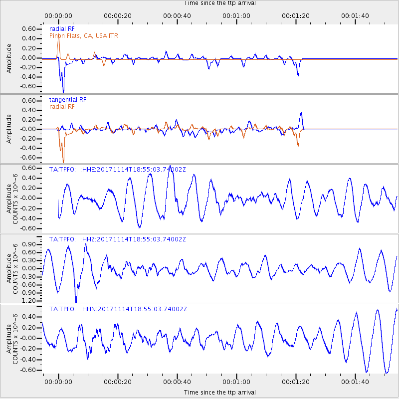
TPFO Pinon Flats, CA, USA - Earthquake Result Viewer
*The percent match for this event was below the threshold and hence no stack was calculated.
| Earthquake location: |
Tonga Islands Region |
| Earthquake latitude/longitude: |
-18.6/-171.5 |
| Earthquake time(UTC): |
2017/11/14 (318) 18:44:00 GMT |
| Earthquake Depth: |
10 km |
| Earthquake Magnitude: |
5.4 Mww |
| Earthquake Catalog/Contributor: |
NEIC PDE/us |
|
| Network: |
TA USArray Transportable Network (new EarthScope stations) |
| Station: |
TPFO Pinon Flats, CA, USA |
| Lat/Lon: |
33.61 N/116.45 W |
| Elevation: |
1275 m |
|
| Distance: |
73.8 deg |
| Az: |
45.423 deg |
| Baz: |
234.037 deg |
| Ray Param: |
$rayparam |
*The percent match for this event was below the threshold and hence was not used in the summary stack. |
|
| Radial Match: |
77.284096 % |
| Radial Bump: |
360 |
| Transverse Match: |
42.44225 % |
| Transverse Bump: |
400 |
| SOD ConfigId: |
13570011 |
| Insert Time: |
2019-04-29 05:19:15.748 +0000 |
| GWidth: |
2.5 |
| Max Bumps: |
400 |
| Tol: |
0.001 |
|
Signal To Noise
| Channel | StoN | STA | LTA |
| TA:TPFO: :HHZ:20171114T18:55:03.74002Z | 1.7997775 | 6.040243E-7 | 3.3561057E-7 |
| TA:TPFO: :HHN:20171114T18:55:03.74002Z | 0.49542293 | 1.6383204E-7 | 3.3069128E-7 |
| TA:TPFO: :HHE:20171114T18:55:03.74002Z | 1.621328 | 3.2368078E-7 | 1.996393E-7 |
| Arrivals |
| Ps | |
| PpPs | |
| PsPs/PpSs | |


