You are here: Home > Network List > TA - USArray Transportable Network (new EarthScope stations) Stations List
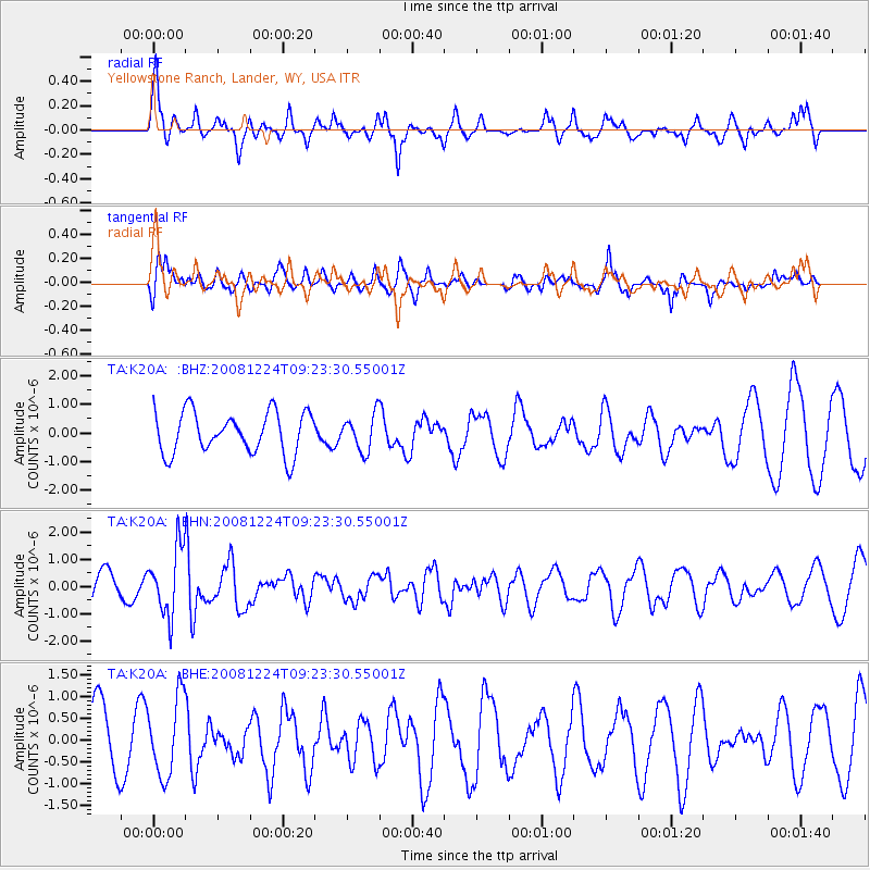
> Station K20A Yellowstone Ranch, Lander, WY, USA > Earthquake Result Viewer
K20A Yellowstone Ranch, Lander, WY, USA - Earthquake Result Viewer
| Earthquake location: |
Tonga Islands Region |
| Earthquake latitude/longitude: |
-17.3/-171.9 |
| Earthquake time(UTC): |
2008/12/24 (359) 09:11:34 GMT |
| Earthquake Depth: |
9.0 km |
| Earthquake Magnitude: |
5.9 MB, 5.6 MS, 6.0 MW, 6.0 MW |
| Earthquake Catalog/Contributor: |
WHDF/NEIC |
|
| Network: |
TA USArray Transportable Network (new EarthScope stations) |
| Station: |
K20A Yellowstone Ranch, Lander, WY, USA |
| Lat/Lon: |
42.66 N/108.34 W |
| Elevation: |
1736 m |
|
| Distance: |
83.4 deg |
| Az: |
41.676 deg |
| Baz: |
239.445 deg |
| Ray Param: |
0.046190485 |
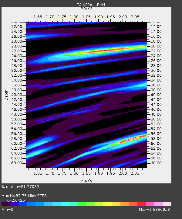
| Estimated Moho Depth: |
57.75 km |
| Estimated Crust Vp/Vs: |
2.04 |
| Assumed Crust Vp: |
6.161 km/s |
| Estimated Crust Vs: |
3.016 km/s |
| Estimated Crust Poisson's Ratio: |
0.34 |
|
| Radial Match: |
81.77033 % |
| Radial Bump: |
400 |
| Transverse Match: |
46.15539 % |
| Transverse Bump: |
298 |
| SOD ConfigId: |
2658 |
| Insert Time: |
2010-03-06 06:29:41.795 +0000 |
| GWidth: |
2.5 |
| Max Bumps: |
400 |
| Tol: |
0.001 |
|
Signal To Noise
| Channel | StoN | STA | LTA |
| TA:K20A: :BHN:20081224T09:23:30.55001Z | 2.392212 | 1.2305036E-6 | 5.14379E-7 |
| TA:K20A: :BHE:20081224T09:23:30.55001Z | 1.1327627 | 9.028793E-7 | 7.9705956E-7 |
| TA:K20A: :BHZ:20081224T09:23:30.55001Z | 0.87615114 | 6.319738E-7 | 7.213069E-7 |
| Arrivals |
| Ps | 10.0 SECOND |
| PpPs | 28 SECOND |
| PsPs/PpSs | 38 SECOND |


