You are here: Home > Network List > IU - Global Seismograph Network (GSN - IRIS/USGS) Stations List
> Station RAR Rarotonga, Cook Islands > Earthquake Result Viewer
RAR Rarotonga, Cook Islands - Earthquake Result Viewer

| Earthquake location: |
Vanuatu Islands |
| Earthquake latitude/longitude: |
-14.4/166.8 |
| Earthquake time(UTC): |
2016/04/03 (094) 08:23:53 GMT |
| Earthquake Depth: |
35 km |
| Earthquake Magnitude: |
6.9 MWW, 7.2 MI |
| Earthquake Catalog/Contributor: |
NEIC PDE/NEIC COMCAT |
|
| Network: |
IU Global Seismograph Network (GSN - IRIS/USGS) |
| Station: |
RAR Rarotonga, Cook Islands |
| Lat/Lon: |
21.21 S/159.77 W |
| Elevation: |
28 m |
|
| Distance: |
32.5 deg |
| Az: |
106.971 deg |
| Baz: |
276.544 deg |
| Ray Param: |
0.07857683 |
| Estimated Moho Depth: |
18.25 km |
| Estimated Crust Vp/Vs: |
1.60 |
| Assumed Crust Vp: |
4.24 km/s |
| Estimated Crust Vs: |
2.65 km/s |
| Estimated Crust Poisson's Ratio: |
0.18 |
|
| Radial Match: |
82.283485 % |
| Radial Bump: |
377 |
| Transverse Match: |
61.606487 % |
| Transverse Bump: |
376 |
| SOD ConfigId: |
1475611 |
| Insert Time: |
2016-04-17 08:39:12.881 +0000 |
| GWidth: |
2.5 |
| Max Bumps: |
400 |
| Tol: |
0.001 |
|
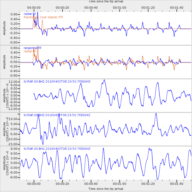
Signal To Noise
| Channel | StoN | STA | LTA |
| IU:RAR:00:BHZ:20160403T08:29:50.768994Z | 2.713948 | 6.7960914E-6 | 2.5041347E-6 |
| IU:RAR:00:BH1:20160403T08:29:50.768994Z | 1.3421292 | 4.780787E-6 | 3.5620917E-6 |
| IU:RAR:00:BH2:20160403T08:29:50.768994Z | 2.266872 | 6.2011627E-6 | 2.7355593E-6 |
| Arrivals |
| Ps | 2.7 SECOND |
| PpPs | 11 SECOND |
| PsPs/PpSs | 13 SECOND |


