You are here: Home > Network List > TA - USArray Transportable Network (new EarthScope stations) Stations List
> Station K20A Yellowstone Ranch, Lander, WY, USA > Earthquake Result Viewer
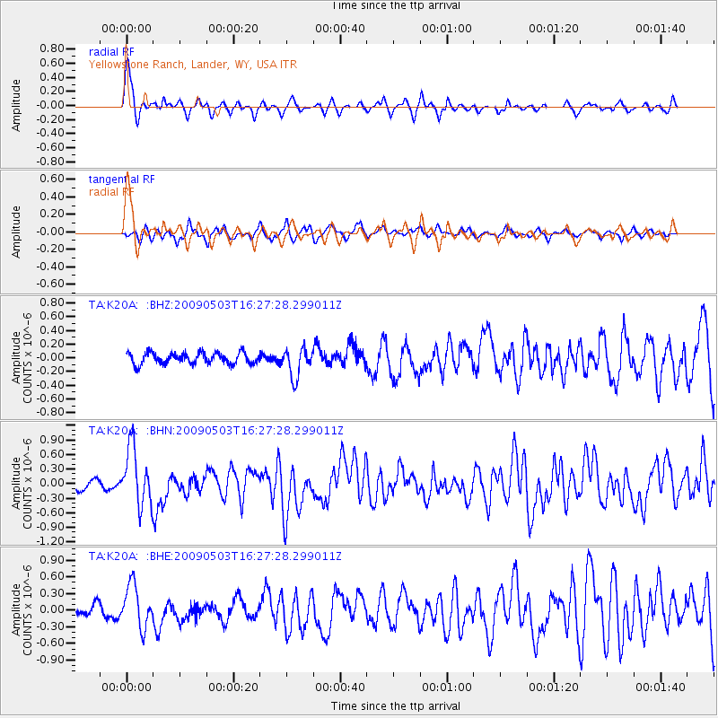
K20A Yellowstone Ranch, Lander, WY, USA - Earthquake Result Viewer
*The percent match for this event was below the threshold and hence no stack was calculated.
| Earthquake location: |
Guatemala |
| Earthquake latitude/longitude: |
14.6/-91.2 |
| Earthquake time(UTC): |
2009/05/03 (123) 16:21:47 GMT |
| Earthquake Depth: |
124 km |
| Earthquake Magnitude: |
5.6 MB, 6.2 MW, 6.2 MW |
| Earthquake Catalog/Contributor: |
WHDF/NEIC |
|
| Network: |
TA USArray Transportable Network (new EarthScope stations) |
| Station: |
K20A Yellowstone Ranch, Lander, WY, USA |
| Lat/Lon: |
42.66 N/108.34 W |
| Elevation: |
1736 m |
|
| Distance: |
31.7 deg |
| Az: |
335.482 deg |
| Baz: |
146.996 deg |
| Ray Param: |
$rayparam |
*The percent match for this event was below the threshold and hence was not used in the summary stack. |
|
| Radial Match: |
75.18575 % |
| Radial Bump: |
381 |
| Transverse Match: |
64.145584 % |
| Transverse Bump: |
400 |
| SOD ConfigId: |
2658 |
| Insert Time: |
2010-03-06 06:30:02.508 +0000 |
| GWidth: |
2.5 |
| Max Bumps: |
400 |
| Tol: |
0.001 |
|
Signal To Noise
| Channel | StoN | STA | LTA |
| TA:K20A: :BHN:20090503T16:27:28.299011Z | 5.7747493 | 5.965631E-7 | 1.0330545E-7 |
| TA:K20A: :BHE:20090503T16:27:28.299011Z | 3.793599 | 3.878445E-7 | 1.02236555E-7 |
| TA:K20A: :BHZ:20090503T16:27:28.299011Z | 2.6132462 | 2.1283381E-7 | 8.144423E-8 |
| Arrivals |
| Ps | |
| PpPs | |
| PsPs/PpSs | |


