You are here: Home > Network List > CI - Caltech Regional Seismic Network Stations List
> Station SMM Simmler, CA, USA > Earthquake Result Viewer
SMM Simmler, CA, USA - Earthquake Result Viewer
*The percent match for this event was below the threshold and hence no stack was calculated.
| Earthquake location: |
South Of Mariana Islands |
| Earthquake latitude/longitude: |
13.1/143.7 |
| Earthquake time(UTC): |
2017/11/15 (319) 00:24:32 GMT |
| Earthquake Depth: |
123 km |
| Earthquake Magnitude: |
5.8 Mww |
| Earthquake Catalog/Contributor: |
NEIC PDE/us |
|
| Network: |
CI Caltech Regional Seismic Network |
| Station: |
SMM Simmler, CA, USA |
| Lat/Lon: |
35.31 N/120.00 W |
| Elevation: |
599 m |
|
| Distance: |
87.6 deg |
| Az: |
54.44 deg |
| Baz: |
284.236 deg |
| Ray Param: |
$rayparam |
*The percent match for this event was below the threshold and hence was not used in the summary stack. |
|
| Radial Match: |
52.753597 % |
| Radial Bump: |
400 |
| Transverse Match: |
81.79554 % |
| Transverse Bump: |
400 |
| SOD ConfigId: |
13570011 |
| Insert Time: |
2019-04-29 05:23:38.821 +0000 |
| GWidth: |
2.5 |
| Max Bumps: |
400 |
| Tol: |
0.001 |
|
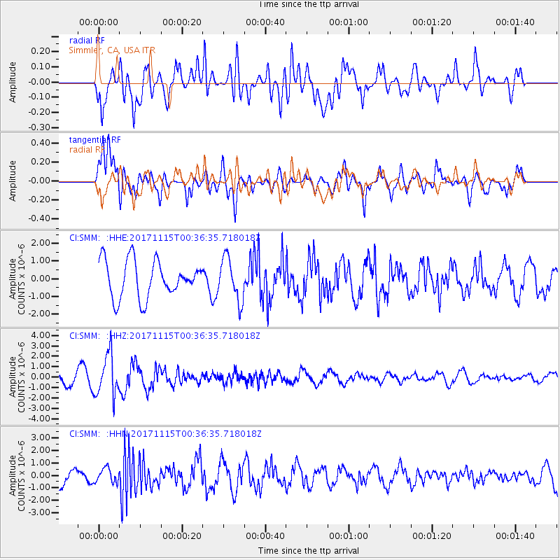
Signal To Noise
| Channel | StoN | STA | LTA |
| CI:SMM: :HHZ:20171115T00:36:35.718018Z | 4.2683864 | 2.0256243E-6 | 4.745644E-7 |
| CI:SMM: :HHN:20171115T00:36:35.718018Z | 0.77104557 | 5.8070117E-7 | 7.5313466E-7 |
| CI:SMM: :HHE:20171115T00:36:35.718018Z | 1.2060702 | 1.2505826E-6 | 1.036907E-6 |
| Arrivals |
| Ps | |
| PpPs | |
| PsPs/PpSs | |


