You are here: Home > Network List > TA - USArray Transportable Network (new EarthScope stations) Stations List
> Station K20A Yellowstone Ranch, Lander, WY, USA > Earthquake Result Viewer
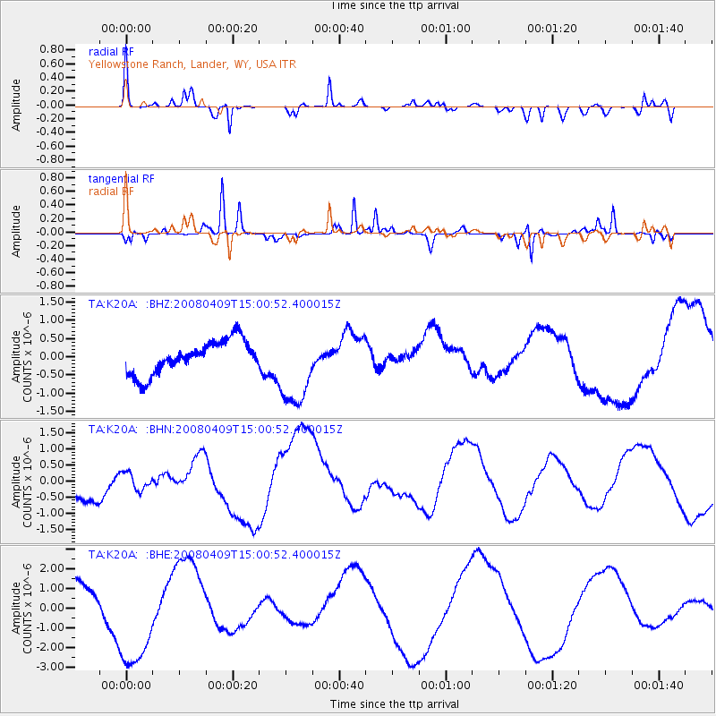
K20A Yellowstone Ranch, Lander, WY, USA - Earthquake Result Viewer
*The percent match for this event was below the threshold and hence no stack was calculated.
| Earthquake location: |
Vanuatu Islands |
| Earthquake latitude/longitude: |
-20.0/168.9 |
| Earthquake time(UTC): |
2008/04/09 (100) 14:47:50 GMT |
| Earthquake Depth: |
35 km |
| Earthquake Magnitude: |
5.9 MB, 6.2 MS, 6.3 MW |
| Earthquake Catalog/Contributor: |
WHDF/NEIC |
|
| Network: |
TA USArray Transportable Network (new EarthScope stations) |
| Station: |
K20A Yellowstone Ranch, Lander, WY, USA |
| Lat/Lon: |
42.66 N/108.34 W |
| Elevation: |
1736 m |
|
| Distance: |
98.2 deg |
| Az: |
47.677 deg |
| Baz: |
250.493 deg |
| Ray Param: |
$rayparam |
*The percent match for this event was below the threshold and hence was not used in the summary stack. |
|
| Radial Match: |
51.08307 % |
| Radial Bump: |
325 |
| Transverse Match: |
67.013275 % |
| Transverse Bump: |
214 |
| SOD ConfigId: |
2504 |
| Insert Time: |
2010-03-06 06:30:43.088 +0000 |
| GWidth: |
2.5 |
| Max Bumps: |
400 |
| Tol: |
0.001 |
|
Signal To Noise
| Channel | StoN | STA | LTA |
| TA:K20A: :BHN:20080409T15:00:52.400015Z | 0.4603005 | 2.6786572E-7 | 5.819366E-7 |
| TA:K20A: :BHE:20080409T15:00:52.400015Z | 2.4006405 | 2.5944696E-6 | 1.0807406E-6 |
| TA:K20A: :BHZ:20080409T15:00:52.400015Z | 2.4282331 | 1.0948185E-6 | 4.508704E-7 |
| Arrivals |
| Ps | |
| PpPs | |
| PsPs/PpSs | |


