You are here: Home > Network List > TA - USArray Transportable Network (new EarthScope stations) Stations List
> Station K20A Yellowstone Ranch, Lander, WY, USA > Earthquake Result Viewer
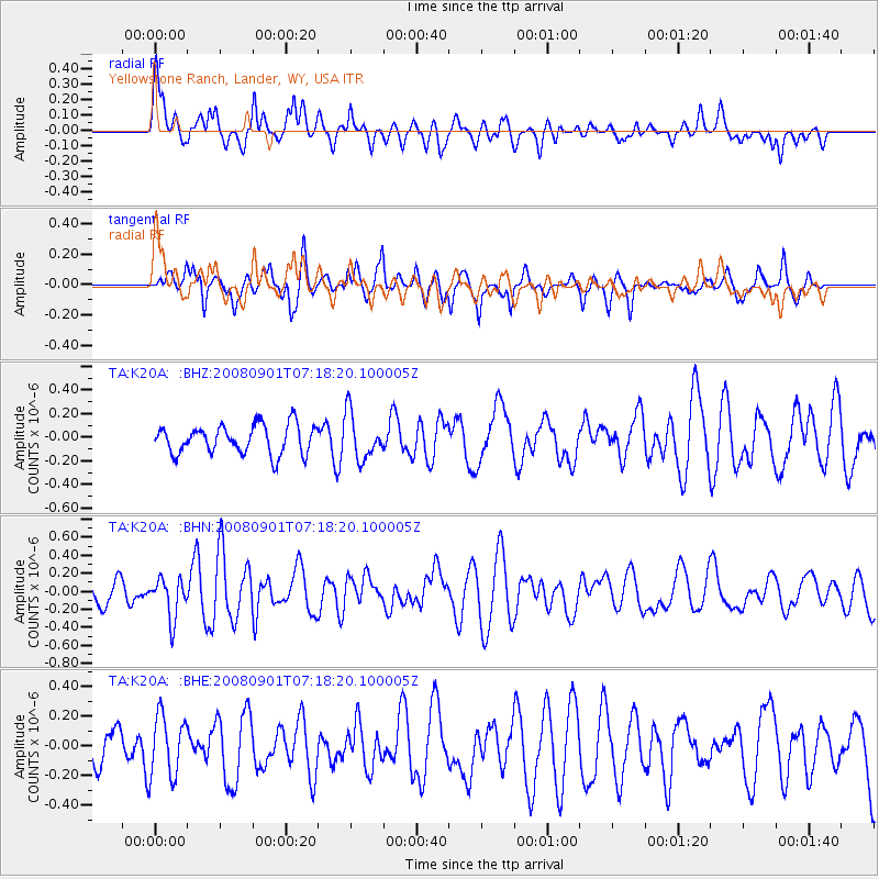
K20A Yellowstone Ranch, Lander, WY, USA - Earthquake Result Viewer
*The percent match for this event was below the threshold and hence no stack was calculated.
| Earthquake location: |
Fiji Islands Region |
| Earthquake latitude/longitude: |
-15.3/-176.4 |
| Earthquake time(UTC): |
2008/09/01 (245) 07:06:16 GMT |
| Earthquake Depth: |
10 km |
| Earthquake Magnitude: |
5.6 MS, 5.4 MB, 5.7 MW, 5.7 MW |
| Earthquake Catalog/Contributor: |
WHDF/NEIC |
|
| Network: |
TA USArray Transportable Network (new EarthScope stations) |
| Station: |
K20A Yellowstone Ranch, Lander, WY, USA |
| Lat/Lon: |
42.66 N/108.34 W |
| Elevation: |
1736 m |
|
| Distance: |
84.9 deg |
| Az: |
43.397 deg |
| Baz: |
244.019 deg |
| Ray Param: |
$rayparam |
*The percent match for this event was below the threshold and hence was not used in the summary stack. |
|
| Radial Match: |
56.15703 % |
| Radial Bump: |
400 |
| Transverse Match: |
68.16681 % |
| Transverse Bump: |
384 |
| SOD ConfigId: |
2504 |
| Insert Time: |
2010-03-06 06:31:12.942 +0000 |
| GWidth: |
2.5 |
| Max Bumps: |
400 |
| Tol: |
0.001 |
|
Signal To Noise
| Channel | StoN | STA | LTA |
| TA:K20A: :BHN:20080901T07:18:20.100005Z | 1.7934922 | 2.2106666E-7 | 1.2326045E-7 |
| TA:K20A: :BHE:20080901T07:18:20.100005Z | 1.3238319 | 2.0546797E-7 | 1.5520699E-7 |
| TA:K20A: :BHZ:20080901T07:18:20.100005Z | 1.5954787 | 1.9329755E-7 | 1.2115332E-7 |
| Arrivals |
| Ps | |
| PpPs | |
| PsPs/PpSs | |


