You are here: Home > Network List > TA - USArray Transportable Network (new EarthScope stations) Stations List
> Station A22K Sinclair Lake, AK, USA > Earthquake Result Viewer
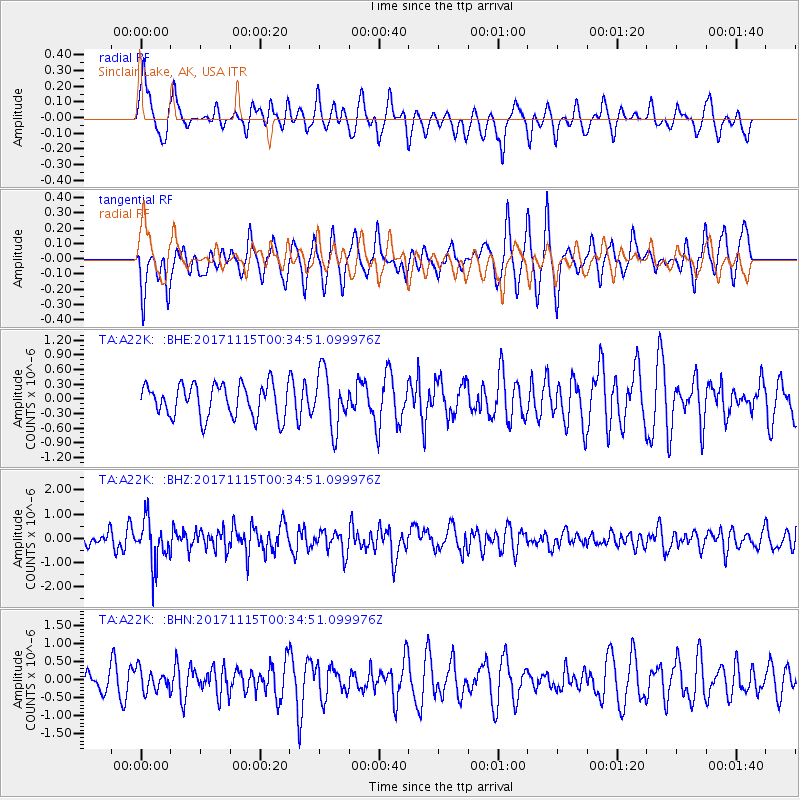
A22K Sinclair Lake, AK, USA - Earthquake Result Viewer
*The percent match for this event was below the threshold and hence no stack was calculated.
| Earthquake location: |
South Of Mariana Islands |
| Earthquake latitude/longitude: |
13.1/143.7 |
| Earthquake time(UTC): |
2017/11/15 (319) 00:24:32 GMT |
| Earthquake Depth: |
123 km |
| Earthquake Magnitude: |
5.8 Mww |
| Earthquake Catalog/Contributor: |
NEIC PDE/us |
|
| Network: |
TA USArray Transportable Network (new EarthScope stations) |
| Station: |
A22K Sinclair Lake, AK, USA |
| Lat/Lon: |
71.00 N/154.97 W |
| Elevation: |
6.0 m |
|
| Distance: |
68.6 deg |
| Az: |
17.984 deg |
| Baz: |
246.738 deg |
| Ray Param: |
$rayparam |
*The percent match for this event was below the threshold and hence was not used in the summary stack. |
|
| Radial Match: |
50.649498 % |
| Radial Bump: |
379 |
| Transverse Match: |
64.35674 % |
| Transverse Bump: |
353 |
| SOD ConfigId: |
13570011 |
| Insert Time: |
2019-04-29 05:26:36.877 +0000 |
| GWidth: |
2.5 |
| Max Bumps: |
400 |
| Tol: |
0.001 |
|
Signal To Noise
| Channel | StoN | STA | LTA |
| TA:A22K: :BHZ:20171115T00:34:51.099976Z | 2.6970463 | 9.301489E-7 | 3.4487687E-7 |
| TA:A22K: :BHN:20171115T00:34:51.099976Z | 0.45276815 | 2.914231E-7 | 6.436476E-7 |
| TA:A22K: :BHE:20171115T00:34:51.099976Z | 1.7097172 | 5.720509E-7 | 3.3458804E-7 |
| Arrivals |
| Ps | |
| PpPs | |
| PsPs/PpSs | |


