You are here: Home > Network List > TA - USArray Transportable Network (new EarthScope stations) Stations List
> Station D25K Kavik River, AK, USA > Earthquake Result Viewer
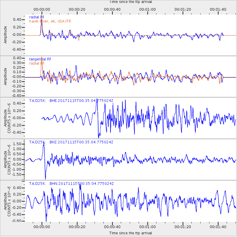
D25K Kavik River, AK, USA - Earthquake Result Viewer
*The percent match for this event was below the threshold and hence no stack was calculated.
| Earthquake location: |
South Of Mariana Islands |
| Earthquake latitude/longitude: |
13.1/143.7 |
| Earthquake time(UTC): |
2017/11/15 (319) 00:24:32 GMT |
| Earthquake Depth: |
123 km |
| Earthquake Magnitude: |
5.8 Mww |
| Earthquake Catalog/Contributor: |
NEIC PDE/us |
|
| Network: |
TA USArray Transportable Network (new EarthScope stations) |
| Station: |
D25K Kavik River, AK, USA |
| Lat/Lon: |
69.32 N/146.38 W |
| Elevation: |
770 m |
|
| Distance: |
70.8 deg |
| Az: |
20.691 deg |
| Baz: |
255.763 deg |
| Ray Param: |
$rayparam |
*The percent match for this event was below the threshold and hence was not used in the summary stack. |
|
| Radial Match: |
73.38804 % |
| Radial Bump: |
400 |
| Transverse Match: |
68.51531 % |
| Transverse Bump: |
400 |
| SOD ConfigId: |
13570011 |
| Insert Time: |
2019-04-29 05:26:48.513 +0000 |
| GWidth: |
2.5 |
| Max Bumps: |
400 |
| Tol: |
0.001 |
|
Signal To Noise
| Channel | StoN | STA | LTA |
| TA:D25K: :BHZ:20171115T00:35:04.775024Z | 10.527171 | 8.1946143E-7 | 7.7842515E-8 |
| TA:D25K: :BHN:20171115T00:35:04.775024Z | 1.7994772 | 2.1439031E-7 | 1.1914033E-7 |
| TA:D25K: :BHE:20171115T00:35:04.775024Z | 4.5633826 | 2.9548218E-7 | 6.475069E-8 |
| Arrivals |
| Ps | |
| PpPs | |
| PsPs/PpSs | |


