You are here: Home > Network List > TA - USArray Transportable Network (new EarthScope stations) Stations List
> Station K20A Yellowstone Ranch, Lander, WY, USA > Earthquake Result Viewer
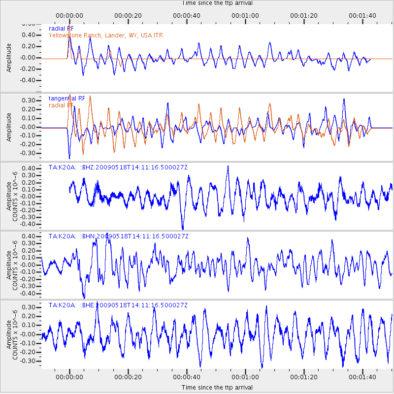
K20A Yellowstone Ranch, Lander, WY, USA - Earthquake Result Viewer
*The percent match for this event was below the threshold and hence no stack was calculated.
| Earthquake location: |
Near Coast Of Peru |
| Earthquake latitude/longitude: |
-15.7/-74.8 |
| Earthquake time(UTC): |
2009/05/18 (138) 14:01:04 GMT |
| Earthquake Depth: |
23 km |
| Earthquake Magnitude: |
5.5 MS, 5.3 MB, 5.8 MW, 5.8 MW |
| Earthquake Catalog/Contributor: |
WHDF/NEIC |
|
| Network: |
TA USArray Transportable Network (new EarthScope stations) |
| Station: |
K20A Yellowstone Ranch, Lander, WY, USA |
| Lat/Lon: |
42.66 N/108.34 W |
| Elevation: |
1736 m |
|
| Distance: |
65.7 deg |
| Az: |
333.464 deg |
| Baz: |
144.306 deg |
| Ray Param: |
$rayparam |
*The percent match for this event was below the threshold and hence was not used in the summary stack. |
|
| Radial Match: |
63.288208 % |
| Radial Bump: |
400 |
| Transverse Match: |
54.22715 % |
| Transverse Bump: |
399 |
| SOD ConfigId: |
2760 |
| Insert Time: |
2010-03-06 06:31:23.145 +0000 |
| GWidth: |
2.5 |
| Max Bumps: |
400 |
| Tol: |
0.001 |
|
Signal To Noise
| Channel | StoN | STA | LTA |
| TA:K20A: :BHN:20090518T14:11:16.500027Z | 2.1527085 | 1.6460427E-7 | 7.64638E-8 |
| TA:K20A: :BHE:20090518T14:11:16.500027Z | 1.0141115 | 8.376068E-8 | 8.2595136E-8 |
| TA:K20A: :BHZ:20090518T14:11:16.500027Z | 1.0739431 | 1.0176977E-7 | 9.476272E-8 |
| Arrivals |
| Ps | |
| PpPs | |
| PsPs/PpSs | |


