You are here: Home > Network List > TA - USArray Transportable Network (new EarthScope stations) Stations List
> Station G23K Bananza Creek, AK, USA > Earthquake Result Viewer
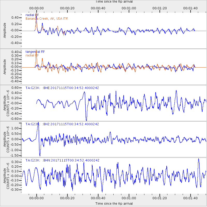
G23K Bananza Creek, AK, USA - Earthquake Result Viewer
*The percent match for this event was below the threshold and hence no stack was calculated.
| Earthquake location: |
South Of Mariana Islands |
| Earthquake latitude/longitude: |
13.1/143.7 |
| Earthquake time(UTC): |
2017/11/15 (319) 00:24:32 GMT |
| Earthquake Depth: |
123 km |
| Earthquake Magnitude: |
5.8 Mww |
| Earthquake Catalog/Contributor: |
NEIC PDE/us |
|
| Network: |
TA USArray Transportable Network (new EarthScope stations) |
| Station: |
G23K Bananza Creek, AK, USA |
| Lat/Lon: |
66.71 N/150.02 W |
| Elevation: |
746 m |
|
| Distance: |
68.8 deg |
| Az: |
22.991 deg |
| Baz: |
253.176 deg |
| Ray Param: |
$rayparam |
*The percent match for this event was below the threshold and hence was not used in the summary stack. |
|
| Radial Match: |
72.63535 % |
| Radial Bump: |
400 |
| Transverse Match: |
55.678528 % |
| Transverse Bump: |
400 |
| SOD ConfigId: |
13570011 |
| Insert Time: |
2019-04-29 05:27:25.902 +0000 |
| GWidth: |
2.5 |
| Max Bumps: |
400 |
| Tol: |
0.001 |
|
Signal To Noise
| Channel | StoN | STA | LTA |
| TA:G23K: :BHZ:20171115T00:34:52.400024Z | 7.131901 | 8.292149E-7 | 1.1626843E-7 |
| TA:G23K: :BHN:20171115T00:34:52.400024Z | 1.2205776 | 1.6173341E-7 | 1.3250563E-7 |
| TA:G23K: :BHE:20171115T00:34:52.400024Z | 3.7675624 | 3.279409E-7 | 8.704326E-8 |
| Arrivals |
| Ps | |
| PpPs | |
| PsPs/PpSs | |


