You are here: Home > Network List > TA - USArray Transportable Network (new EarthScope stations) Stations List
> Station K20A Yellowstone Ranch, Lander, WY, USA > Earthquake Result Viewer
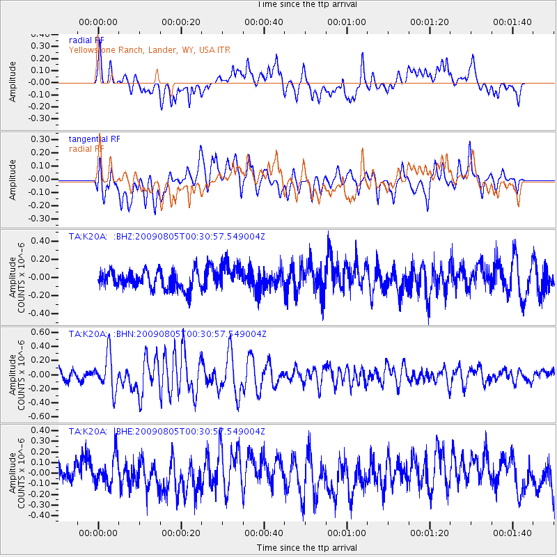
K20A Yellowstone Ranch, Lander, WY, USA - Earthquake Result Viewer
*The percent match for this event was below the threshold and hence no stack was calculated.
| Earthquake location: |
Southwestern Ryukyu Isl., Japan |
| Earthquake latitude/longitude: |
24.2/125.1 |
| Earthquake time(UTC): |
2009/08/05 (217) 00:17:58 GMT |
| Earthquake Depth: |
25 km |
| Earthquake Magnitude: |
5.9 MB, 5.9 MS, 6.2 MW, 6.1 MW |
| Earthquake Catalog/Contributor: |
WHDF/NEIC |
|
| Network: |
TA USArray Transportable Network (new EarthScope stations) |
| Station: |
K20A Yellowstone Ranch, Lander, WY, USA |
| Lat/Lon: |
42.66 N/108.34 W |
| Elevation: |
1736 m |
|
| Distance: |
97.2 deg |
| Az: |
36.672 deg |
| Baz: |
312.345 deg |
| Ray Param: |
$rayparam |
*The percent match for this event was below the threshold and hence was not used in the summary stack. |
|
| Radial Match: |
61.29454 % |
| Radial Bump: |
400 |
| Transverse Match: |
61.700985 % |
| Transverse Bump: |
400 |
| SOD ConfigId: |
2622 |
| Insert Time: |
2010-03-06 06:31:30.408 +0000 |
| GWidth: |
2.5 |
| Max Bumps: |
400 |
| Tol: |
0.001 |
|
Signal To Noise
| Channel | StoN | STA | LTA |
| TA:K20A: :BHN:20090805T00:30:57.549004Z | 3.7479248 | 2.6196784E-7 | 6.989677E-8 |
| TA:K20A: :BHE:20090805T00:30:57.549004Z | 1.2687516 | 1.3973384E-7 | 1.10134906E-7 |
| TA:K20A: :BHZ:20090805T00:30:57.549004Z | 1.5375555 | 1.5074522E-7 | 9.8042136E-8 |
| Arrivals |
| Ps | |
| PpPs | |
| PsPs/PpSs | |


