You are here: Home > Network List > US - United States National Seismic Network Stations List
> Station MNTX Cornudas Mountains, Texas, USA > Earthquake Result Viewer
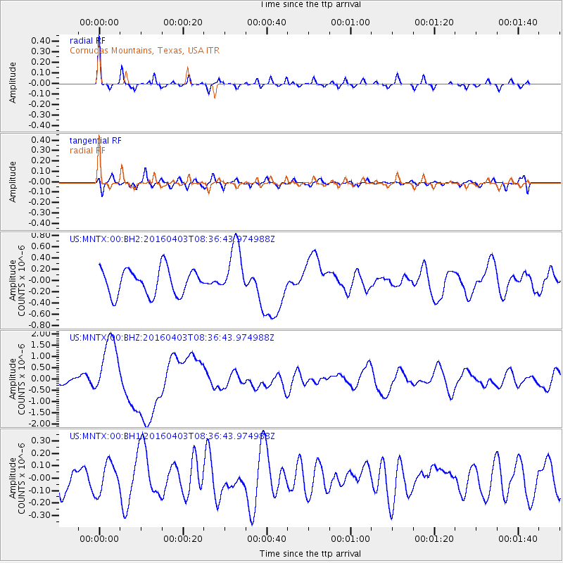
MNTX Cornudas Mountains, Texas, USA - Earthquake Result Viewer
*The percent match for this event was below the threshold and hence no stack was calculated.
| Earthquake location: |
Vanuatu Islands |
| Earthquake latitude/longitude: |
-14.4/166.8 |
| Earthquake time(UTC): |
2016/04/03 (094) 08:23:53 GMT |
| Earthquake Depth: |
35 km |
| Earthquake Magnitude: |
6.9 MWW, 7.2 MI |
| Earthquake Catalog/Contributor: |
NEIC PDE/NEIC COMCAT |
|
| Network: |
US United States National Seismic Network |
| Station: |
MNTX Cornudas Mountains, Texas, USA |
| Lat/Lon: |
31.70 N/105.38 W |
| Elevation: |
404 m |
|
| Distance: |
95.6 deg |
| Az: |
58.849 deg |
| Baz: |
256.672 deg |
| Ray Param: |
$rayparam |
*The percent match for this event was below the threshold and hence was not used in the summary stack. |
|
| Radial Match: |
69.57282 % |
| Radial Bump: |
292 |
| Transverse Match: |
65.63123 % |
| Transverse Bump: |
400 |
| SOD ConfigId: |
1475611 |
| Insert Time: |
2016-04-17 08:50:47.560 +0000 |
| GWidth: |
2.5 |
| Max Bumps: |
400 |
| Tol: |
0.001 |
|
Signal To Noise
| Channel | StoN | STA | LTA |
| US:MNTX:00:BHZ:20160403T08:36:43.974988Z | 7.305558 | 1.3386991E-6 | 1.8324391E-7 |
| US:MNTX:00:BH1:20160403T08:36:43.974988Z | 0.9616776 | 1.2089268E-7 | 1.257102E-7 |
| US:MNTX:00:BH2:20160403T08:36:43.974988Z | 2.0480313 | 4.7406016E-7 | 2.3147113E-7 |
| Arrivals |
| Ps | |
| PpPs | |
| PsPs/PpSs | |


