You are here: Home > Network List > TA - USArray Transportable Network (new EarthScope stations) Stations List
> Station L20K Farewell, AK, USA > Earthquake Result Viewer
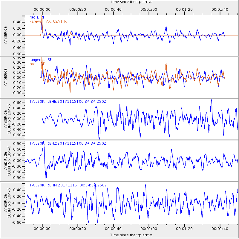
L20K Farewell, AK, USA - Earthquake Result Viewer
*The percent match for this event was below the threshold and hence no stack was calculated.
| Earthquake location: |
South Of Mariana Islands |
| Earthquake latitude/longitude: |
13.1/143.7 |
| Earthquake time(UTC): |
2017/11/15 (319) 00:24:32 GMT |
| Earthquake Depth: |
123 km |
| Earthquake Magnitude: |
5.8 Mww |
| Earthquake Catalog/Contributor: |
NEIC PDE/us |
|
| Network: |
TA USArray Transportable Network (new EarthScope stations) |
| Station: |
L20K Farewell, AK, USA |
| Lat/Lon: |
62.48 N/153.88 W |
| Elevation: |
673 m |
|
| Distance: |
65.9 deg |
| Az: |
26.821 deg |
| Baz: |
251.171 deg |
| Ray Param: |
$rayparam |
*The percent match for this event was below the threshold and hence was not used in the summary stack. |
|
| Radial Match: |
57.35845 % |
| Radial Bump: |
400 |
| Transverse Match: |
54.764416 % |
| Transverse Bump: |
400 |
| SOD ConfigId: |
13570011 |
| Insert Time: |
2019-04-29 05:28:02.415 +0000 |
| GWidth: |
2.5 |
| Max Bumps: |
400 |
| Tol: |
0.001 |
|
Signal To Noise
| Channel | StoN | STA | LTA |
| TA:L20K: :BHZ:20171115T00:34:34.250Z | 6.400055 | 5.401549E-7 | 8.439848E-8 |
| TA:L20K: :BHN:20171115T00:34:34.250Z | 0.79614216 | 1.1139861E-7 | 1.3992302E-7 |
| TA:L20K: :BHE:20171115T00:34:34.250Z | 2.7895658 | 3.7764178E-7 | 1.3537654E-7 |
| Arrivals |
| Ps | |
| PpPs | |
| PsPs/PpSs | |


