You are here: Home > Network List > TA - USArray Transportable Network (new EarthScope stations) Stations List
> Station TPFO Pinon Flats, CA, USA > Earthquake Result Viewer
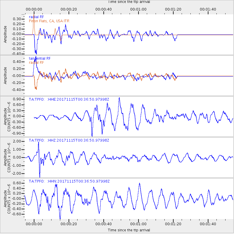
TPFO Pinon Flats, CA, USA - Earthquake Result Viewer
*The percent match for this event was below the threshold and hence no stack was calculated.
| Earthquake location: |
South Of Mariana Islands |
| Earthquake latitude/longitude: |
13.1/143.7 |
| Earthquake time(UTC): |
2017/11/15 (319) 00:24:32 GMT |
| Earthquake Depth: |
123 km |
| Earthquake Magnitude: |
5.8 Mww |
| Earthquake Catalog/Contributor: |
NEIC PDE/us |
|
| Network: |
TA USArray Transportable Network (new EarthScope stations) |
| Station: |
TPFO Pinon Flats, CA, USA |
| Lat/Lon: |
33.61 N/116.45 W |
| Elevation: |
1275 m |
|
| Distance: |
90.9 deg |
| Az: |
55.314 deg |
| Baz: |
286.243 deg |
| Ray Param: |
$rayparam |
*The percent match for this event was below the threshold and hence was not used in the summary stack. |
|
| Radial Match: |
90.06448 % |
| Radial Bump: |
400 |
| Transverse Match: |
72.17274 % |
| Transverse Bump: |
400 |
| SOD ConfigId: |
13570011 |
| Insert Time: |
2019-04-29 05:28:41.358 +0000 |
| GWidth: |
2.5 |
| Max Bumps: |
400 |
| Tol: |
0.001 |
|
Signal To Noise
| Channel | StoN | STA | LTA |
| TA:TPFO: :HHZ:20171115T00:36:50.97998Z | 3.4319675 | 8.7037455E-7 | 2.5360805E-7 |
| TA:TPFO: :HHN:20171115T00:36:50.97998Z | 1.0667566 | 2.8426987E-7 | 2.6648055E-7 |
| TA:TPFO: :HHE:20171115T00:36:50.97998Z | 4.2710752 | 3.8509108E-7 | 9.0162565E-8 |
| Arrivals |
| Ps | |
| PpPs | |
| PsPs/PpSs | |


