You are here: Home > Network List > TA - USArray Transportable Network (new EarthScope stations) Stations List
> Station K20A Yellowstone Ranch, Lander, WY, USA > Earthquake Result Viewer
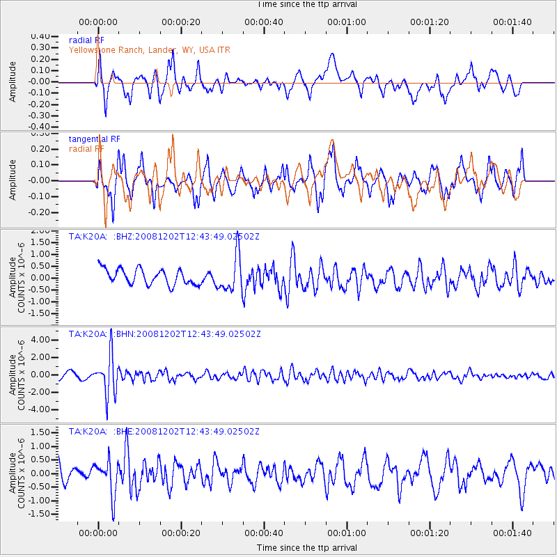
K20A Yellowstone Ranch, Lander, WY, USA - Earthquake Result Viewer
*The percent match for this event was below the threshold and hence no stack was calculated.
| Earthquake location: |
Mariana Islands |
| Earthquake latitude/longitude: |
19.1/145.8 |
| Earthquake time(UTC): |
2008/12/02 (337) 12:31:43 GMT |
| Earthquake Depth: |
137 km |
| Earthquake Magnitude: |
5.9 MB, 5.9 MW, 5.9 MW |
| Earthquake Catalog/Contributor: |
WHDF/NEIC |
|
| Network: |
TA USArray Transportable Network (new EarthScope stations) |
| Station: |
K20A Yellowstone Ranch, Lander, WY, USA |
| Lat/Lon: |
42.66 N/108.34 W |
| Elevation: |
1736 m |
|
| Distance: |
88.4 deg |
| Az: |
45.212 deg |
| Baz: |
294.531 deg |
| Ray Param: |
$rayparam |
*The percent match for this event was below the threshold and hence was not used in the summary stack. |
|
| Radial Match: |
63.578976 % |
| Radial Bump: |
400 |
| Transverse Match: |
71.55702 % |
| Transverse Bump: |
359 |
| SOD ConfigId: |
2658 |
| Insert Time: |
2010-03-06 06:31:58.091 +0000 |
| GWidth: |
2.5 |
| Max Bumps: |
400 |
| Tol: |
0.001 |
|
Signal To Noise
| Channel | StoN | STA | LTA |
| TA:K20A: :BHN:20081202T12:43:49.02502Z | 8.265639 | 2.2951044E-6 | 2.776681E-7 |
| TA:K20A: :BHE:20081202T12:43:49.02502Z | 1.7871188 | 6.5547306E-7 | 3.6677642E-7 |
| TA:K20A: :BHZ:20081202T12:43:49.02502Z | 2.4576015 | 8.033606E-7 | 3.2688806E-7 |
| Arrivals |
| Ps | |
| PpPs | |
| PsPs/PpSs | |


