You are here: Home > Network List > TA - USArray Transportable Network (new EarthScope stations) Stations List
> Station K20A Yellowstone Ranch, Lander, WY, USA > Earthquake Result Viewer
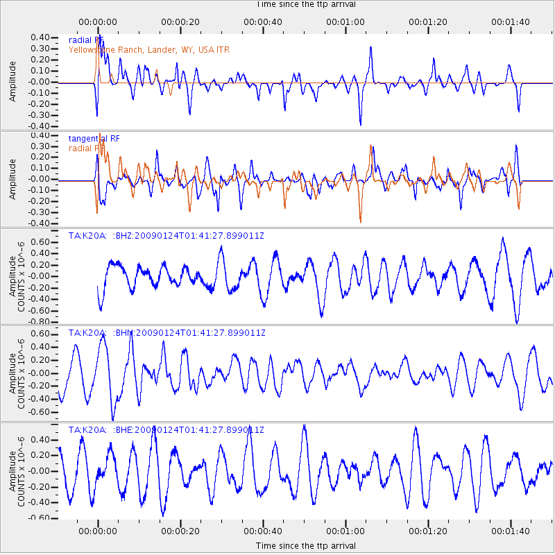
K20A Yellowstone Ranch, Lander, WY, USA - Earthquake Result Viewer
*The percent match for this event was below the threshold and hence no stack was calculated.
| Earthquake location: |
Kermadec Islands Region |
| Earthquake latitude/longitude: |
-28.2/-176.7 |
| Earthquake time(UTC): |
2009/01/24 (024) 01:28:39 GMT |
| Earthquake Depth: |
10 km |
| Earthquake Magnitude: |
5.5 MB, 5.8 MS, 6.0 MW, 5.8 MW |
| Earthquake Catalog/Contributor: |
WHDF/NEIC |
|
| Network: |
TA USArray Transportable Network (new EarthScope stations) |
| Station: |
K20A Yellowstone Ranch, Lander, WY, USA |
| Lat/Lon: |
42.66 N/108.34 W |
| Elevation: |
1736 m |
|
| Distance: |
94.5 deg |
| Az: |
43.452 deg |
| Baz: |
235.336 deg |
| Ray Param: |
$rayparam |
*The percent match for this event was below the threshold and hence was not used in the summary stack. |
|
| Radial Match: |
65.13345 % |
| Radial Bump: |
400 |
| Transverse Match: |
61.982998 % |
| Transverse Bump: |
400 |
| SOD ConfigId: |
2658 |
| Insert Time: |
2010-03-06 06:32:38.917 +0000 |
| GWidth: |
2.5 |
| Max Bumps: |
400 |
| Tol: |
0.001 |
|
Signal To Noise
| Channel | StoN | STA | LTA |
| TA:K20A: :BHN:20090124T01:41:27.899011Z | 2.1072967 | 4.3552555E-7 | 2.0667501E-7 |
| TA:K20A: :BHE:20090124T01:41:27.899011Z | 0.90713644 | 1.862999E-7 | 2.053714E-7 |
| TA:K20A: :BHZ:20090124T01:41:27.899011Z | 1.4520774 | 2.7052E-7 | 1.862986E-7 |
| Arrivals |
| Ps | |
| PpPs | |
| PsPs/PpSs | |


