You are here: Home > Network List > TA - USArray Transportable Network (new EarthScope stations) Stations List
> Station K20A Yellowstone Ranch, Lander, WY, USA > Earthquake Result Viewer
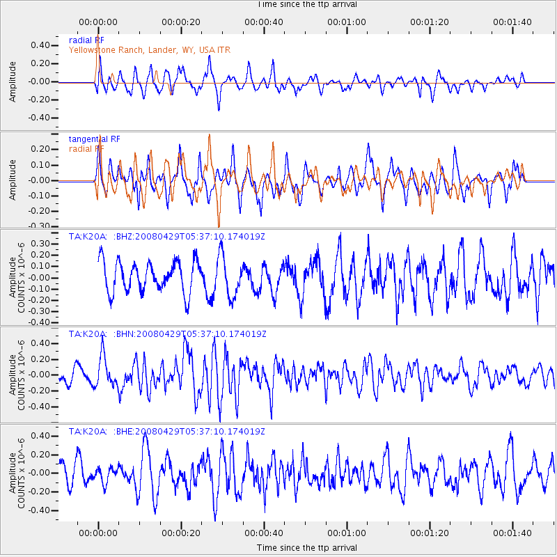
K20A Yellowstone Ranch, Lander, WY, USA - Earthquake Result Viewer
*The percent match for this event was below the threshold and hence no stack was calculated.
| Earthquake location: |
Hokkaido, Japan Region |
| Earthquake latitude/longitude: |
41.5/142.0 |
| Earthquake time(UTC): |
2008/04/29 (120) 05:26:04 GMT |
| Earthquake Depth: |
47 km |
| Earthquake Magnitude: |
5.5 MB, 5.2 MS, 5.8 MW, 5.8 MW |
| Earthquake Catalog/Contributor: |
WHDF/NEIC |
|
| Network: |
TA USArray Transportable Network (new EarthScope stations) |
| Station: |
K20A Yellowstone Ranch, Lander, WY, USA |
| Lat/Lon: |
42.66 N/108.34 W |
| Elevation: |
1736 m |
|
| Distance: |
75.0 deg |
| Az: |
46.001 deg |
| Baz: |
312.858 deg |
| Ray Param: |
$rayparam |
*The percent match for this event was below the threshold and hence was not used in the summary stack. |
|
| Radial Match: |
52.016117 % |
| Radial Bump: |
400 |
| Transverse Match: |
56.648563 % |
| Transverse Bump: |
364 |
| SOD ConfigId: |
2504 |
| Insert Time: |
2010-03-06 06:32:56.536 +0000 |
| GWidth: |
2.5 |
| Max Bumps: |
400 |
| Tol: |
0.001 |
|
Signal To Noise
| Channel | StoN | STA | LTA |
| TA:K20A: :BHN:20080429T05:37:10.174019Z | 1.9067667 | 1.940125E-7 | 1.0174948E-7 |
| TA:K20A: :BHE:20080429T05:37:10.174019Z | 0.62211037 | 7.995463E-8 | 1.2852162E-7 |
| TA:K20A: :BHZ:20080429T05:37:10.174019Z | 1.3611947 | 1.8270634E-7 | 1.3422499E-7 |
| Arrivals |
| Ps | |
| PpPs | |
| PsPs/PpSs | |


