You are here: Home > Network List > TA - USArray Transportable Network (new EarthScope stations) Stations List
> Station M31M Drury Creek, Yukon, CA > Earthquake Result Viewer
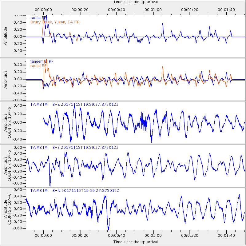
M31M Drury Creek, Yukon, CA - Earthquake Result Viewer
*The percent match for this event was below the threshold and hence no stack was calculated.
| Earthquake location: |
Eastern Caucasus |
| Earthquake latitude/longitude: |
40.3/47.3 |
| Earthquake time(UTC): |
2017/11/15 (319) 19:48:03 GMT |
| Earthquake Depth: |
23 km |
| Earthquake Magnitude: |
5.2 Mww |
| Earthquake Catalog/Contributor: |
NEIC PDE/us |
|
| Network: |
TA USArray Transportable Network (new EarthScope stations) |
| Station: |
M31M Drury Creek, Yukon, CA |
| Lat/Lon: |
62.20 N/134.39 W |
| Elevation: |
639 m |
|
| Distance: |
77.8 deg |
| Az: |
0.827 deg |
| Baz: |
358.65 deg |
| Ray Param: |
$rayparam |
*The percent match for this event was below the threshold and hence was not used in the summary stack. |
|
| Radial Match: |
73.229614 % |
| Radial Bump: |
400 |
| Transverse Match: |
42.874622 % |
| Transverse Bump: |
371 |
| SOD ConfigId: |
13570011 |
| Insert Time: |
2019-04-29 05:37:50.869 +0000 |
| GWidth: |
2.5 |
| Max Bumps: |
400 |
| Tol: |
0.001 |
|
Signal To Noise
| Channel | StoN | STA | LTA |
| TA:M31M: :BHZ:20171115T19:59:27.875012Z | 2.126182 | 2.4046358E-7 | 1.13096426E-7 |
| TA:M31M: :BHN:20171115T19:59:27.875012Z | 0.43323871 | 9.435299E-8 | 2.1778523E-7 |
| TA:M31M: :BHE:20171115T19:59:27.875012Z | 0.8295312 | 1.7232259E-7 | 2.077349E-7 |
| Arrivals |
| Ps | |
| PpPs | |
| PsPs/PpSs | |


