You are here: Home > Network List > TA - USArray Transportable Network (new EarthScope stations) Stations List
> Station 115A Sonoran Desert, Stanfield, AZ, USA > Earthquake Result Viewer
115A Sonoran Desert, Stanfield, AZ, USA - Earthquake Result Viewer
| Earthquake location: |
Eastern Honshu, Japan |
| Earthquake latitude/longitude: |
39.8/141.5 |
| Earthquake time(UTC): |
2008/07/23 (205) 15:26:19 GMT |
| Earthquake Depth: |
108 km |
| Earthquake Magnitude: |
6.6 MB, 6.8 MW, 6.8 MW |
| Earthquake Catalog/Contributor: |
WHDF/NEIC |
|
| Network: |
TA USArray Transportable Network (new EarthScope stations) |
| Station: |
115A Sonoran Desert, Stanfield, AZ, USA |
| Lat/Lon: |
32.70 N/112.23 W |
| Elevation: |
606 m |
|
| Distance: |
80.8 deg |
| Az: |
55.069 deg |
| Baz: |
311.489 deg |
| Ray Param: |
0.04781082 |
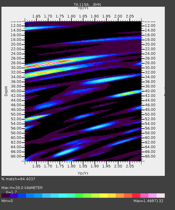
| Estimated Moho Depth: |
28.0 km |
| Estimated Crust Vp/Vs: |
1.70 |
| Assumed Crust Vp: |
6.264 km/s |
| Estimated Crust Vs: |
3.684 km/s |
| Estimated Crust Poisson's Ratio: |
0.24 |
|
| Radial Match: |
94.4037 % |
| Radial Bump: |
400 |
| Transverse Match: |
84.10251 % |
| Transverse Bump: |
400 |
| SOD ConfigId: |
2504 |
| Insert Time: |
2010-03-06 06:33:43.855 +0000 |
| GWidth: |
2.5 |
| Max Bumps: |
400 |
| Tol: |
0.001 |
|

Signal To Noise
| Channel | StoN | STA | LTA |
| TA:115A: :BHN:20080723T15:37:50.423999Z | 33.628094 | 3.5712521E-6 | 1.0619847E-7 |
| TA:115A: :BHE:20080723T15:37:50.423999Z | 6.4946218 | 8.161453E-7 | 1.256648E-7 |
| TA:115A: :BHZ:20080723T15:37:50.423999Z | 7.7014766 | 1.0679435E-6 | 1.3866736E-7 |
| Arrivals |
| Ps | 3.2 SECOND |
| PpPs | 12 SECOND |
| PsPs/PpSs | 15 SECOND |


