You are here: Home > Network List > TA - USArray Transportable Network (new EarthScope stations) Stations List
> Station R33M Jennings River, BC, CAN > Earthquake Result Viewer
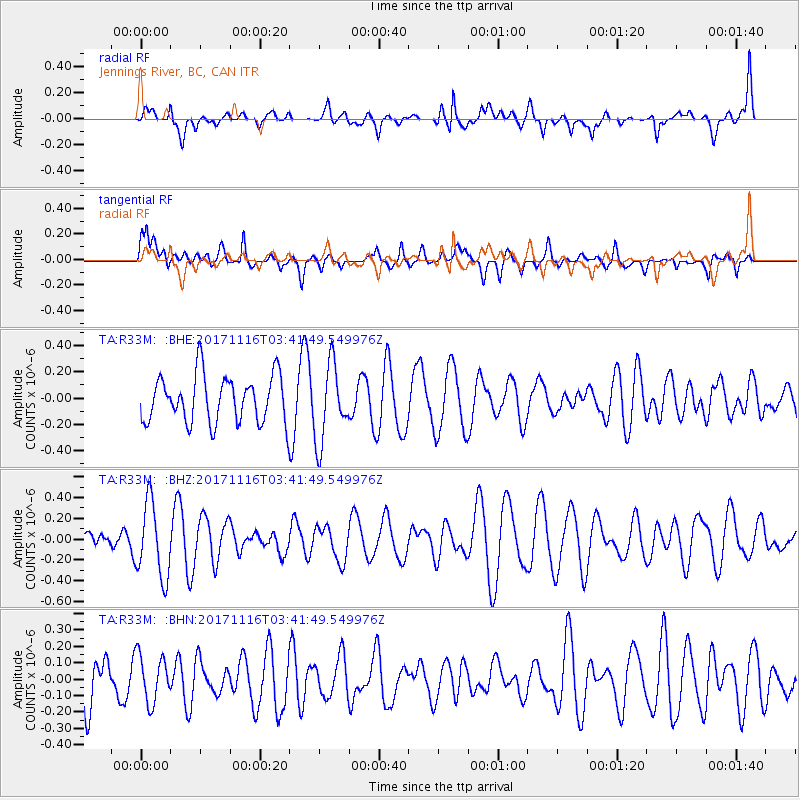
R33M Jennings River, BC, CAN - Earthquake Result Viewer
*The percent match for this event was below the threshold and hence no stack was calculated.
| Earthquake location: |
Loyalty Islands |
| Earthquake latitude/longitude: |
-21.6/168.5 |
| Earthquake time(UTC): |
2017/11/16 (320) 03:29:00 GMT |
| Earthquake Depth: |
12 km |
| Earthquake Magnitude: |
5.3 mb |
| Earthquake Catalog/Contributor: |
NEIC PDE/us |
|
| Network: |
TA USArray Transportable Network (new EarthScope stations) |
| Station: |
R33M Jennings River, BC, CAN |
| Lat/Lon: |
59.39 N/130.97 W |
| Elevation: |
1437 m |
|
| Distance: |
94.6 deg |
| Az: |
26.552 deg |
| Baz: |
234.403 deg |
| Ray Param: |
$rayparam |
*The percent match for this event was below the threshold and hence was not used in the summary stack. |
|
| Radial Match: |
46.848843 % |
| Radial Bump: |
400 |
| Transverse Match: |
54.725918 % |
| Transverse Bump: |
400 |
| SOD ConfigId: |
13570011 |
| Insert Time: |
2019-04-29 05:48:00.309 +0000 |
| GWidth: |
2.5 |
| Max Bumps: |
400 |
| Tol: |
0.001 |
|
Signal To Noise
| Channel | StoN | STA | LTA |
| TA:R33M: :BHZ:20171116T03:41:49.549976Z | 2.1135104 | 3.602222E-7 | 1.7043787E-7 |
| TA:R33M: :BHN:20171116T03:41:49.549976Z | 0.78271955 | 1.449879E-7 | 1.8523606E-7 |
| TA:R33M: :BHE:20171116T03:41:49.549976Z | 1.6387147 | 2.9282404E-7 | 1.786913E-7 |
| Arrivals |
| Ps | |
| PpPs | |
| PsPs/PpSs | |


