You are here: Home > Network List > TA - USArray Transportable Network (new EarthScope stations) Stations List
> Station 115A Sonoran Desert, Stanfield, AZ, USA > Earthquake Result Viewer
115A Sonoran Desert, Stanfield, AZ, USA - Earthquake Result Viewer

| Earthquake location: |
Solomon Islands |
| Earthquake latitude/longitude: |
-10.9/162.1 |
| Earthquake time(UTC): |
2007/11/27 (331) 11:49:58 GMT |
| Earthquake Depth: |
16 km |
| Earthquake Magnitude: |
5.9 MB, 6.7 MS, 6.6 MW, 6.4 MW |
| Earthquake Catalog/Contributor: |
WHDF/NEIC |
|
| Network: |
TA USArray Transportable Network (new EarthScope stations) |
| Station: |
115A Sonoran Desert, Stanfield, AZ, USA |
| Lat/Lon: |
32.70 N/112.23 W |
| Elevation: |
606 m |
|
| Distance: |
92.2 deg |
| Az: |
57.278 deg |
| Baz: |
258.488 deg |
| Ray Param: |
0.041493107 |
| Estimated Moho Depth: |
29.75 km |
| Estimated Crust Vp/Vs: |
1.74 |
| Assumed Crust Vp: |
6.264 km/s |
| Estimated Crust Vs: |
3.605 km/s |
| Estimated Crust Poisson's Ratio: |
0.25 |
|
| Radial Match: |
86.263565 % |
| Radial Bump: |
400 |
| Transverse Match: |
65.21921 % |
| Transverse Bump: |
400 |
| SOD ConfigId: |
2564 |
| Insert Time: |
2010-03-06 06:34:10.231 +0000 |
| GWidth: |
2.5 |
| Max Bumps: |
400 |
| Tol: |
0.001 |
|
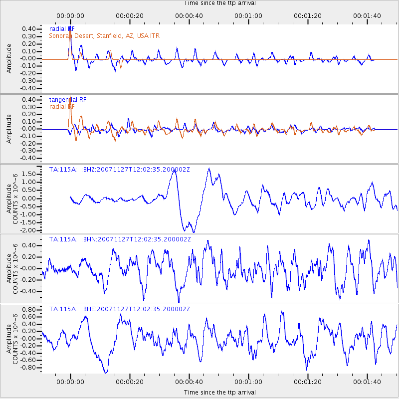
Signal To Noise
| Channel | StoN | STA | LTA |
| TA:115A: :BHN:20071127T12:02:35.200002Z | 0.9156758 | 1.1935215E-7 | 1.3034324E-7 |
| TA:115A: :BHE:20071127T12:02:35.200002Z | 2.251438 | 2.8772718E-7 | 1.2779707E-7 |
| TA:115A: :BHZ:20071127T12:02:35.200002Z | 5.7299547 | 7.928938E-7 | 1.3837698E-7 |
| Arrivals |
| Ps | 3.6 SECOND |
| PpPs | 13 SECOND |
| PsPs/PpSs | 16 SECOND |


