You are here: Home > Network List > TA - USArray Transportable Network (new EarthScope stations) Stations List
> Station 115A Sonoran Desert, Stanfield, AZ, USA > Earthquake Result Viewer
115A Sonoran Desert, Stanfield, AZ, USA - Earthquake Result Viewer
| Earthquake location: |
Volcano Islands, Japan Region |
| Earthquake latitude/longitude: |
22.0/142.7 |
| Earthquake time(UTC): |
2007/09/28 (271) 13:38:59 GMT |
| Earthquake Depth: |
276 km |
| Earthquake Magnitude: |
6.7 MB, 7.4 MW, 7.4 MW |
| Earthquake Catalog/Contributor: |
WHDF/NEIC |
|
| Network: |
TA USArray Transportable Network (new EarthScope stations) |
| Station: |
115A Sonoran Desert, Stanfield, AZ, USA |
| Lat/Lon: |
32.70 N/112.23 W |
| Elevation: |
606 m |
|
| Distance: |
90.2 deg |
| Az: |
54.485 deg |
| Baz: |
296.375 deg |
| Ray Param: |
0.041625425 |
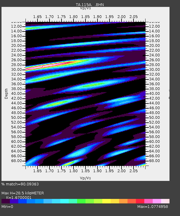
| Estimated Moho Depth: |
28.5 km |
| Estimated Crust Vp/Vs: |
1.67 |
| Assumed Crust Vp: |
6.264 km/s |
| Estimated Crust Vs: |
3.751 km/s |
| Estimated Crust Poisson's Ratio: |
0.22 |
|
| Radial Match: |
90.09363 % |
| Radial Bump: |
400 |
| Transverse Match: |
77.8876 % |
| Transverse Bump: |
400 |
| SOD ConfigId: |
2564 |
| Insert Time: |
2010-03-06 06:34:23.018 +0000 |
| GWidth: |
2.5 |
| Max Bumps: |
400 |
| Tol: |
0.001 |
|

Signal To Noise
| Channel | StoN | STA | LTA |
| TA:115A: :BHN:20070928T13:50:57.550Z | 23.016321 | 1.4158394E-6 | 6.1514584E-8 |
| TA:115A: :BHE:20070928T13:50:57.550Z | 32.34725 | 3.676205E-6 | 1.1364814E-7 |
| TA:115A: :BHZ:20070928T13:50:57.550Z | 98.66947 | 1.0631156E-5 | 1.0774514E-7 |
| Arrivals |
| Ps | 3.1 SECOND |
| PpPs | 12 SECOND |
| PsPs/PpSs | 15 SECOND |


