You are here: Home > Network List > AT - Alaska Tsunami Warning Seismic System Stations List
> Station OHAK Old Harbor, Alaska > Earthquake Result Viewer
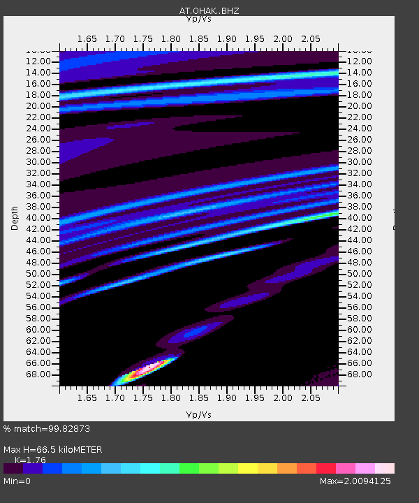
OHAK Old Harbor, Alaska - Earthquake Result Viewer
| Earthquake location: |
Loyalty Islands |
| Earthquake latitude/longitude: |
-21.5/168.5 |
| Earthquake time(UTC): |
2017/11/16 (320) 07:02:38 GMT |
| Earthquake Depth: |
10 km |
| Earthquake Magnitude: |
5.9 Mww |
| Earthquake Catalog/Contributor: |
NEIC PDE/us |
|
| Network: |
AT Alaska Tsunami Warning Seismic System |
| Station: |
OHAK Old Harbor, Alaska |
| Lat/Lon: |
57.22 N/153.29 W |
| Elevation: |
78 m |
|
| Distance: |
84.7 deg |
| Az: |
19.758 deg |
| Baz: |
215.356 deg |
| Ray Param: |
0.04527194 |
| Estimated Moho Depth: |
66.5 km |
| Estimated Crust Vp/Vs: |
1.76 |
| Assumed Crust Vp: |
6.134 km/s |
| Estimated Crust Vs: |
3.485 km/s |
| Estimated Crust Poisson's Ratio: |
0.26 |
|
| Radial Match: |
99.82873 % |
| Radial Bump: |
31 |
| Transverse Match: |
99.838326 % |
| Transverse Bump: |
38 |
| SOD ConfigId: |
13570011 |
| Insert Time: |
2019-04-29 05:49:44.829 +0000 |
| GWidth: |
2.5 |
| Max Bumps: |
400 |
| Tol: |
0.001 |
|

Signal To Noise
| Channel | StoN | STA | LTA |
| AT:OHAK: :BHZ:20171116T07:14:40.840015Z | 11.8239355 | 9.0159466E-7 | 7.625166E-8 |
| AT:OHAK: :BHN:20171116T07:14:40.840015Z | 11.3156595 | 4.8485195E-5 | 4.2847873E-6 |
| AT:OHAK: :BHE:20171116T07:14:40.840015Z | 8.110556 | 5.398974E-7 | 6.656725E-8 |
| Arrivals |
| Ps | 8.4 SECOND |
| PpPs | 29 SECOND |
| PsPs/PpSs | 38 SECOND |


