You are here: Home > Network List > CI - Caltech Regional Seismic Network Stations List
> Station MPP McPhearson Peak > Earthquake Result Viewer
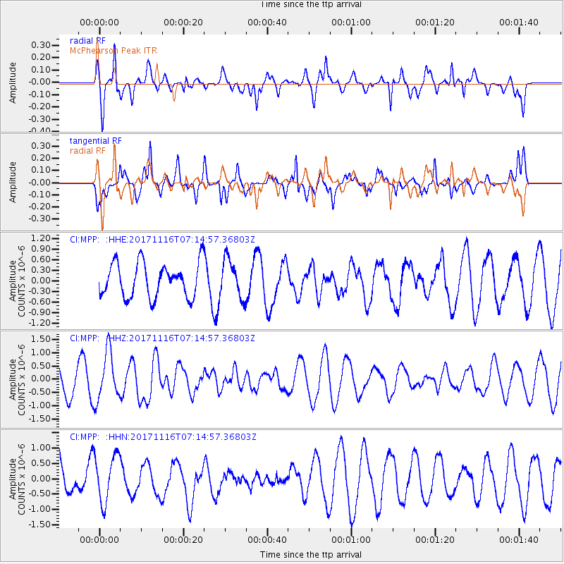
MPP McPhearson Peak - Earthquake Result Viewer
*The percent match for this event was below the threshold and hence no stack was calculated.
| Earthquake location: |
Loyalty Islands |
| Earthquake latitude/longitude: |
-21.5/168.5 |
| Earthquake time(UTC): |
2017/11/16 (320) 07:02:38 GMT |
| Earthquake Depth: |
10 km |
| Earthquake Magnitude: |
5.9 Mww |
| Earthquake Catalog/Contributor: |
NEIC PDE/us |
|
| Network: |
CI Caltech Regional Seismic Network |
| Station: |
MPP McPhearson Peak |
| Lat/Lon: |
34.89 N/119.81 W |
| Elevation: |
1739 m |
|
| Distance: |
88.1 deg |
| Az: |
51.345 deg |
| Baz: |
242.193 deg |
| Ray Param: |
$rayparam |
*The percent match for this event was below the threshold and hence was not used in the summary stack. |
|
| Radial Match: |
64.90026 % |
| Radial Bump: |
400 |
| Transverse Match: |
62.451046 % |
| Transverse Bump: |
400 |
| SOD ConfigId: |
13570011 |
| Insert Time: |
2019-04-29 05:50:48.289 +0000 |
| GWidth: |
2.5 |
| Max Bumps: |
400 |
| Tol: |
0.001 |
|
Signal To Noise
| Channel | StoN | STA | LTA |
| CI:MPP: :HHZ:20171116T07:14:57.36803Z | 2.0819104 | 9.099456E-7 | 4.370724E-7 |
| CI:MPP: :HHN:20171116T07:14:57.36803Z | 0.92848414 | 7.6075963E-7 | 8.193566E-7 |
| CI:MPP: :HHE:20171116T07:14:57.36803Z | 1.1502773 | 5.642187E-7 | 4.905067E-7 |
| Arrivals |
| Ps | |
| PpPs | |
| PsPs/PpSs | |


