You are here: Home > Network List > TA - USArray Transportable Network (new EarthScope stations) Stations List
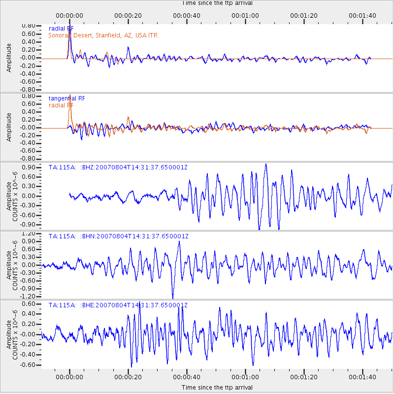
> Station 115A Sonoran Desert, Stanfield, AZ, USA > Earthquake Result Viewer
115A Sonoran Desert, Stanfield, AZ, USA - Earthquake Result Viewer
| Earthquake location: |
Central East Pacific Rise |
| Earthquake latitude/longitude: |
-4.8/-105.4 |
| Earthquake time(UTC): |
2007/08/04 (216) 14:24:51 GMT |
| Earthquake Depth: |
10 km |
| Earthquake Magnitude: |
5.7 MS, 5.4 MB, 6.0 MW, 5.9 MW |
| Earthquake Catalog/Contributor: |
WHDF/NEIC |
|
| Network: |
TA USArray Transportable Network (new EarthScope stations) |
| Station: |
115A Sonoran Desert, Stanfield, AZ, USA |
| Lat/Lon: |
32.70 N/112.23 W |
| Elevation: |
606 m |
|
| Distance: |
37.8 deg |
| Az: |
350.606 deg |
| Baz: |
168.877 deg |
| Ray Param: |
0.0759023 |
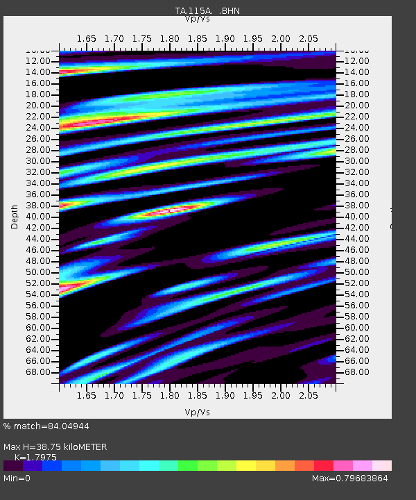
| Estimated Moho Depth: |
38.75 km |
| Estimated Crust Vp/Vs: |
1.80 |
| Assumed Crust Vp: |
6.264 km/s |
| Estimated Crust Vs: |
3.485 km/s |
| Estimated Crust Poisson's Ratio: |
0.28 |
|
| Radial Match: |
84.04944 % |
| Radial Bump: |
400 |
| Transverse Match: |
66.08197 % |
| Transverse Bump: |
400 |
| SOD ConfigId: |
2564 |
| Insert Time: |
2010-03-06 06:34:47.218 +0000 |
| GWidth: |
2.5 |
| Max Bumps: |
400 |
| Tol: |
0.001 |
|
Signal To Noise
| Channel | StoN | STA | LTA |
| TA:115A: :BHN:20070804T14:31:37.650001Z | 1.5225278 | 1.310994E-7 | 8.6106404E-8 |
| TA:115A: :BHE:20070804T14:31:37.650001Z | 1.2001364 | 9.101436E-8 | 7.583668E-8 |
| TA:115A: :BHZ:20070804T14:31:37.650001Z | 1.2956083 | 1.1419847E-7 | 8.814274E-8 |
| Arrivals |
| Ps | 5.3 SECOND |
| PpPs | 16 SECOND |
| PsPs/PpSs | 21 SECOND |


