You are here: Home > Network List > TA - USArray Transportable Network (new EarthScope stations) Stations List
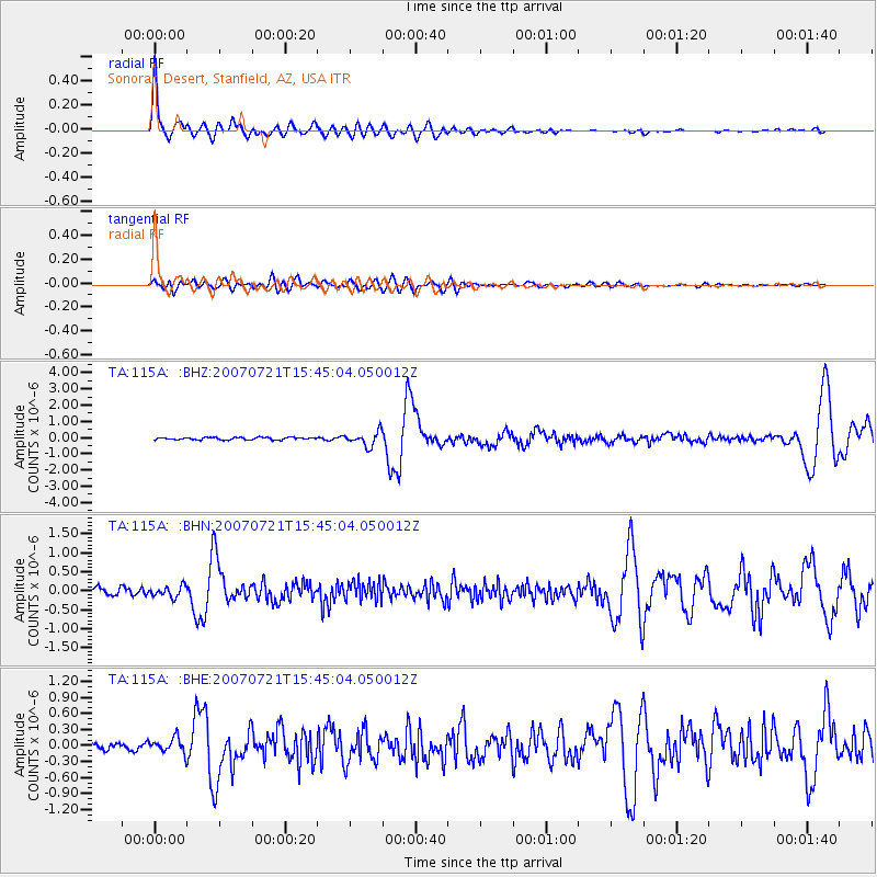
> Station 115A Sonoran Desert, Stanfield, AZ, USA > Earthquake Result Viewer
115A Sonoran Desert, Stanfield, AZ, USA - Earthquake Result Viewer
| Earthquake location: |
Jujuy Province, Argentina |
| Earthquake latitude/longitude: |
-22.2/-65.8 |
| Earthquake time(UTC): |
2007/07/21 (202) 15:34:52 GMT |
| Earthquake Depth: |
290 km |
| Earthquake Magnitude: |
5.8 MB, 6.4 MW, 6.3 MW |
| Earthquake Catalog/Contributor: |
WHDF/NEIC |
|
| Network: |
TA USArray Transportable Network (new EarthScope stations) |
| Station: |
115A Sonoran Desert, Stanfield, AZ, USA |
| Lat/Lon: |
32.70 N/112.23 W |
| Elevation: |
606 m |
|
| Distance: |
70.3 deg |
| Az: |
319.529 deg |
| Baz: |
134.466 deg |
| Ray Param: |
0.054221753 |
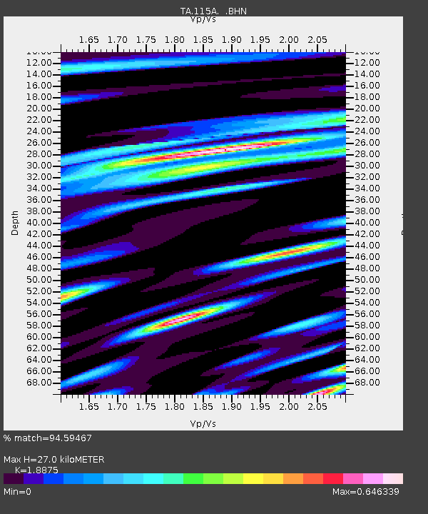
| Estimated Moho Depth: |
27.0 km |
| Estimated Crust Vp/Vs: |
1.89 |
| Assumed Crust Vp: |
6.264 km/s |
| Estimated Crust Vs: |
3.318 km/s |
| Estimated Crust Poisson's Ratio: |
0.30 |
|
| Radial Match: |
94.59467 % |
| Radial Bump: |
400 |
| Transverse Match: |
67.42784 % |
| Transverse Bump: |
400 |
| SOD ConfigId: |
2564 |
| Insert Time: |
2010-03-06 06:34:55.656 +0000 |
| GWidth: |
2.5 |
| Max Bumps: |
400 |
| Tol: |
0.001 |
|
Signal To Noise
| Channel | StoN | STA | LTA |
| TA:115A: :BHN:20070721T15:45:04.050012Z | 1.6589955 | 1.4226234E-7 | 8.575209E-8 |
| TA:115A: :BHE:20070721T15:45:04.050012Z | 2.1804614 | 1.4146977E-7 | 6.488066E-8 |
| TA:115A: :BHZ:20070721T15:45:04.050012Z | 5.9333005 | 4.3137132E-7 | 7.2703436E-8 |
| Arrivals |
| Ps | 3.9 SECOND |
| PpPs | 12 SECOND |
| PsPs/PpSs | 16 SECOND |


