You are here: Home > Network List > TA - USArray Transportable Network (new EarthScope stations) Stations List
> Station K13K Kusilvak Mountain, AK, USA > Earthquake Result Viewer
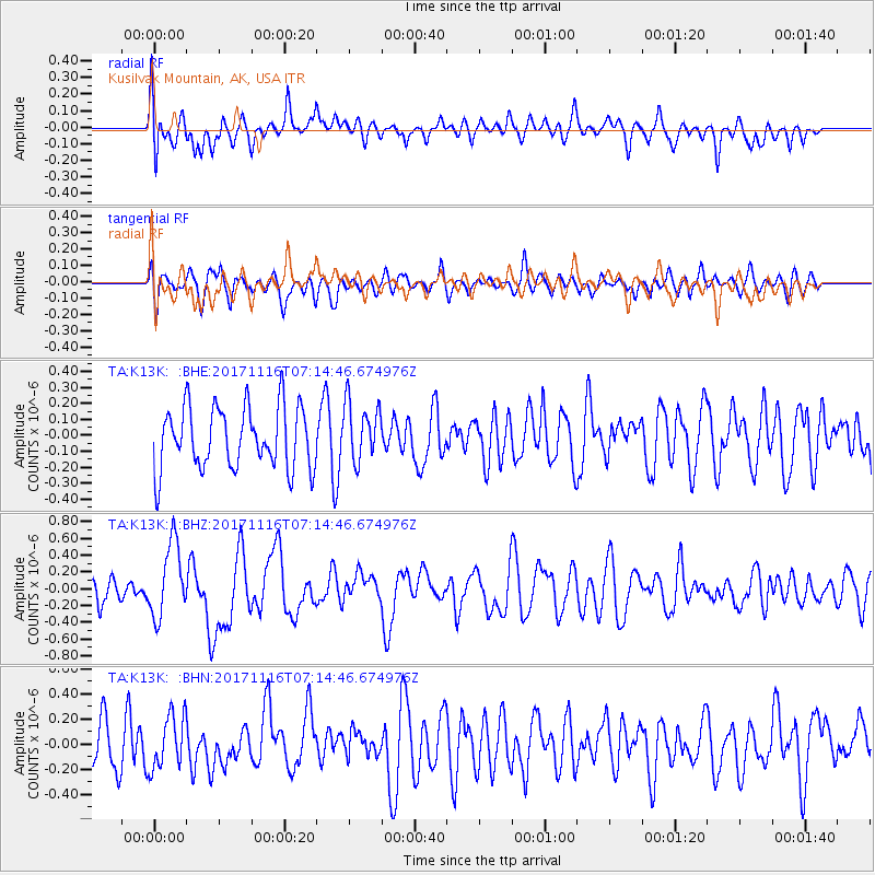
K13K Kusilvak Mountain, AK, USA - Earthquake Result Viewer
*The percent match for this event was below the threshold and hence no stack was calculated.
| Earthquake location: |
Loyalty Islands |
| Earthquake latitude/longitude: |
-21.5/168.5 |
| Earthquake time(UTC): |
2017/11/16 (320) 07:02:38 GMT |
| Earthquake Depth: |
10 km |
| Earthquake Magnitude: |
5.9 Mww |
| Earthquake Catalog/Contributor: |
NEIC PDE/us |
|
| Network: |
TA USArray Transportable Network (new EarthScope stations) |
| Station: |
K13K Kusilvak Mountain, AK, USA |
| Lat/Lon: |
61.93 N/164.66 W |
| Elevation: |
204 m |
|
| Distance: |
85.9 deg |
| Az: |
12.372 deg |
| Baz: |
204.949 deg |
| Ray Param: |
$rayparam |
*The percent match for this event was below the threshold and hence was not used in the summary stack. |
|
| Radial Match: |
45.74616 % |
| Radial Bump: |
400 |
| Transverse Match: |
45.75003 % |
| Transverse Bump: |
400 |
| SOD ConfigId: |
13570011 |
| Insert Time: |
2019-04-29 05:52:48.712 +0000 |
| GWidth: |
2.5 |
| Max Bumps: |
400 |
| Tol: |
0.001 |
|
Signal To Noise
| Channel | StoN | STA | LTA |
| TA:K13K: :BHZ:20171116T07:14:46.674976Z | 2.644287 | 4.4006825E-7 | 1.6642227E-7 |
| TA:K13K: :BHN:20171116T07:14:46.674976Z | 0.9321464 | 2.1382736E-7 | 2.2939247E-7 |
| TA:K13K: :BHE:20171116T07:14:46.674976Z | 0.94336337 | 1.8236265E-7 | 1.9331114E-7 |
| Arrivals |
| Ps | |
| PpPs | |
| PsPs/PpSs | |


