You are here: Home > Network List > TA - USArray Transportable Network (new EarthScope stations) Stations List
> Station 115A Sonoran Desert, Stanfield, AZ, USA > Earthquake Result Viewer
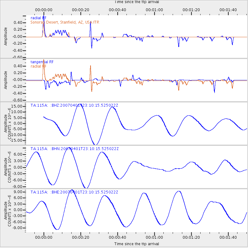
115A Sonoran Desert, Stanfield, AZ, USA - Earthquake Result Viewer

| Earthquake location: |
Solomon Islands |
| Earthquake latitude/longitude: |
-7.5/156.1 |
| Earthquake time(UTC): |
2007/04/01 (091) 22:57:23 GMT |
| Earthquake Depth: |
18 km |
| Earthquake Magnitude: |
5.7 MB |
| Earthquake Catalog/Contributor: |
WHDF/NEIC |
|
| Network: |
TA USArray Transportable Network (new EarthScope stations) |
| Station: |
115A Sonoran Desert, Stanfield, AZ, USA |
| Lat/Lon: |
32.70 N/112.23 W |
| Elevation: |
606 m |
|
| Distance: |
95.5 deg |
| Az: |
57.844 deg |
| Baz: |
264.593 deg |
| Ray Param: |
0.04077309 |
| Estimated Moho Depth: |
57.5 km |
| Estimated Crust Vp/Vs: |
1.81 |
| Assumed Crust Vp: |
6.264 km/s |
| Estimated Crust Vs: |
3.465 km/s |
| Estimated Crust Poisson's Ratio: |
0.28 |
|
| Radial Match: |
92.80216 % |
| Radial Bump: |
400 |
| Transverse Match: |
78.824455 % |
| Transverse Bump: |
375 |
| SOD ConfigId: |
2564 |
| Insert Time: |
2010-03-06 06:35:19.886 +0000 |
| GWidth: |
2.5 |
| Max Bumps: |
400 |
| Tol: |
0.001 |
|
Signal To Noise
| Channel | StoN | STA | LTA |
| TA:115A: :BHN:20070401T23:10:15.525022Z | 0.94924617 | 5.5341434E-6 | 5.83004E-6 |
| TA:115A: :BHE:20070401T23:10:15.525022Z | 1.3677727 | 3.7911454E-6 | 2.7717658E-6 |
| TA:115A: :BHZ:20070401T23:10:15.525022Z | 1.3754252 | 1.1424393E-5 | 8.306081E-6 |
| Arrivals |
| Ps | 7.6 SECOND |
| PpPs | 25 SECOND |
| PsPs/PpSs | 33 SECOND |


