You are here: Home > Network List > YT07 - POLENET Stations List
> Station WAWA WAWA > Earthquake Result Viewer
WAWA WAWA - Earthquake Result Viewer
| Earthquake location: |
Loyalty Islands |
| Earthquake latitude/longitude: |
-21.5/168.5 |
| Earthquake time(UTC): |
2017/11/16 (320) 07:02:38 GMT |
| Earthquake Depth: |
10 km |
| Earthquake Magnitude: |
5.9 Mww |
| Earthquake Catalog/Contributor: |
NEIC PDE/us |
|
| Network: |
YT POLENET |
| Station: |
WAWA WAWA |
| Lat/Lon: |
81.58 S/28.42 W |
| Elevation: |
1202 m |
|
| Distance: |
76.7 deg |
| Az: |
177.476 deg |
| Baz: |
196.149 deg |
| Ray Param: |
0.05079216 |
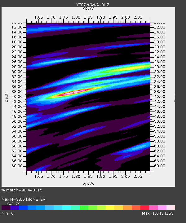
| Estimated Moho Depth: |
38.0 km |
| Estimated Crust Vp/Vs: |
1.79 |
| Assumed Crust Vp: |
6.424 km/s |
| Estimated Crust Vs: |
3.589 km/s |
| Estimated Crust Poisson's Ratio: |
0.27 |
|
| Radial Match: |
90.440315 % |
| Radial Bump: |
354 |
| Transverse Match: |
84.21021 % |
| Transverse Bump: |
400 |
| SOD ConfigId: |
13570011 |
| Insert Time: |
2019-04-29 05:54:27.277 +0000 |
| GWidth: |
2.5 |
| Max Bumps: |
400 |
| Tol: |
0.001 |
|

Signal To Noise
| Channel | StoN | STA | LTA |
| YT:WAWA: :BHZ:20171116T07:13:58.049976Z | 10.183316 | 1.0937273E-6 | 1.0740384E-7 |
| YT:WAWA: :BHN:20171116T07:13:58.049976Z | 6.1636972 | 3.8476878E-7 | 6.2425E-8 |
| YT:WAWA: :BHE:20171116T07:13:58.049976Z | 2.1668746 | 1.3632135E-7 | 6.2911504E-8 |
| Arrivals |
| Ps | 4.8 SECOND |
| PpPs | 16 SECOND |
| PsPs/PpSs | 21 SECOND |


