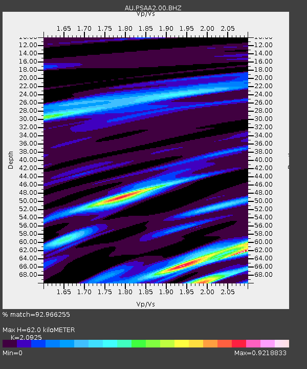
PSAA2 Pilbara Seismic Array Element A2 - Earthquake Result Viewer

Earthquake location: Vanuatu Islands
Earthquake latitude/longitude: -14.1/166.6
Earthquake time(UTC): 2016/04/06 (097) 06:58:48 GMT
Earthquake Depth: 24 km
Earthquake Magnitude: 6.7 MWW, 6.6 MWB, 6.7 MWC, 6.9 MI
Earthquake Catalog/Contributor: NEIC PDE/NEIC COMCAT
Network: AU Australian Seismological Centre
Station: PSAA2 Pilbara Seismic Array Element A2
Lat/Lon: 21.56 S/119.85 E
Elevation: 330 m
Distance: 45.0 deg
Az: 253.538 deg
Baz: 88.552 deg
Ray Param: 0.071533
Estimated Moho Depth: 62.0 km
Estimated Crust Vp/Vs: 2.09
Assumed Crust Vp: 6.464 km/s
Estimated Crust Vs: 3.089 km/s
Estimated Crust Poisson's Ratio: 0.35
Radial Match: 92.966255 %
Radial Bump: 400
Transverse Match: 86.07037 %
Transverse Bump: 400
SOD ConfigId: 1475611
Insert Time: 2016-04-20 06:59:55.391 +0000
GWidth: 2.5
Max Bumps: 400
Tol: 0.001

Signal To Noise

ChannelStoNSTALTA
AU:PSAA2:00:BHZ:20160406T07:06:31.319011Z8.8054292.896695E-63.289669E-7
AU:PSAA2:00:BH1:20160406T07:06:31.319011Z5.5411671.7662724E-63.187546E-7
AU:PSAA2:00:BH2:20160406T07:06:31.319011Z0.64173251.5261514E-72.3781737E-7
Arrivals
Ps11 SECOND
PpPs28 SECOND
PsPs/PpSs39 SECOND