You are here: Home > Network List > TA - USArray Transportable Network (new EarthScope stations) Stations List
> Station 115A Sonoran Desert, Stanfield, AZ, USA > Earthquake Result Viewer
115A Sonoran Desert, Stanfield, AZ, USA - Earthquake Result Viewer
| Earthquake location: |
Kuril Islands |
| Earthquake latitude/longitude: |
46.6/153.3 |
| Earthquake time(UTC): |
2006/11/15 (319) 11:14:13 GMT |
| Earthquake Depth: |
10 km |
| Earthquake Magnitude: |
6.5 MB, 7.8 MS, 8.3 MW, 7.9 MW |
| Earthquake Catalog/Contributor: |
WHDF/NEIC |
|
| Network: |
TA USArray Transportable Network (new EarthScope stations) |
| Station: |
115A Sonoran Desert, Stanfield, AZ, USA |
| Lat/Lon: |
32.70 N/112.23 W |
| Elevation: |
606 m |
|
| Distance: |
69.9 deg |
| Az: |
63.517 deg |
| Baz: |
312.938 deg |
| Ray Param: |
0.055340976 |
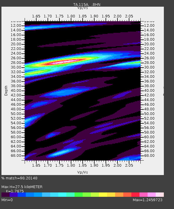
| Estimated Moho Depth: |
27.5 km |
| Estimated Crust Vp/Vs: |
1.77 |
| Assumed Crust Vp: |
6.264 km/s |
| Estimated Crust Vs: |
3.544 km/s |
| Estimated Crust Poisson's Ratio: |
0.26 |
|
| Radial Match: |
98.20148 % |
| Radial Bump: |
328 |
| Transverse Match: |
93.62907 % |
| Transverse Bump: |
400 |
| SOD ConfigId: |
2564 |
| Insert Time: |
2010-03-06 06:35:37.116 +0000 |
| GWidth: |
2.5 |
| Max Bumps: |
400 |
| Tol: |
0.001 |
|
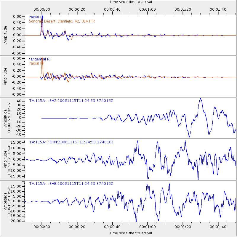
Signal To Noise
| Channel | StoN | STA | LTA |
| TA:115A: :BHN:20061115T11:24:53.374016Z | 2.7395523 | 6.8040015E-7 | 2.483618E-7 |
| TA:115A: :BHE:20061115T11:24:53.374016Z | 2.338245 | 5.669491E-7 | 2.424678E-7 |
| TA:115A: :BHZ:20061115T11:24:53.374016Z | 7.171569 | 1.51697E-6 | 2.1152553E-7 |
| Arrivals |
| Ps | 3.5 SECOND |
| PpPs | 12 SECOND |
| PsPs/PpSs | 15 SECOND |


